< Back to all GCSE Cheat Sheets
AQA Geography GCSE - Complete Revision Cheat Sheet! (8035)
NOTE: Paper 1 and 2 are complete. 3 will be added later.
Latest update: 30/09/2023 13:32.
Latest content addition: 20/05/2023 22:25
READ THIS:
Please use your class notes, if you have any, as well as this, to aid your revision. Although this document matches the specification 1:1 and covers it entirely, it is condensed into one place, so might not cover everything in 100% detail. I have tried to write more content for the topics/ideas which people may find confusing. If there are any errors then please let me know immediately (Discord: @draggie). I have tried my best to make it as easy as possible to understand and get a top grade ;)
I did get a grade 9 in the 2022 exam series, and I did get people coming out of the exam room thanking me for making this, especially for the case studies.
More specifically, here were my exact marks if you’re interested:
Paper 1: 68/88 [77% - 1 mark/1% above Grade 9, too close!]
Paper 2: 81.02/88 [92% - 13 marks/15% above Grade 9] (scaled mark)
Paper 3: 65.14/76 [86% - 7 marks/10% above Grade 9] (scaled mark)
Total: 214 [85% - 21 marks/8% above Grade 9]
Looking to ace your exams with easy-to-access, free 1:1 advice from exam survivors? Discuss with other students, developers, educators and professionals in the Baguette Brigaders Discord server who can answer all your questions and give you tips and tricks! Plus, you can opt to receive automatic notifications whenever new content is added here!
If images appear slightly pixelated, zoom in to 110%, it’s much crisper.
This cheat sheet covers all of the specification for all 3 papers
… so there’s quite a lot of stuff to digest!
Paper 1: Living with the physical environment
Section A: The challenge of natural hazards
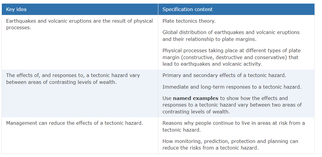
Natural hazards

Specification for 1A
A natural hazard is a natural event which poses risk to human life and assets. The more humans that come into contact with natural events, the more the risk of natural hazards.
Natural hazards are commonly classified by their physical processes which occurred to cause them. These include:
- tectonic hazards, which involve movements of tectonic plates in the Earth’s crust
- atmospheric hazards, such as tropical storms
- geomorphological hazards, such as flooding, which occur on the Earth’s surface
- biological hazards, which involve living organisms, such as forest fires
The magnitude and frequency of these natural hazards are increasing thanks to human factors, such as the greenhouse effect. This increases the risk of extreme weather events, such as more extreme hurricanes.
However, people choose to live in hazardous areas for a variety of reasons. For example, in LICs, the authorities may not have enough money to accurately predict the location, time and magnitude of an event, such as a volcanic eruption, resulting in more people affected by the impact of it. Pull factors to these areas including availability of resources, like crude oil and job opportunities, may also encourage people to move or stay in these at-risk areas.
Tectonic hazards
(Date done in class: 15th-29th September 2020)
Examples of tectonic hazards include earthquakes or tsunamis.
The plate tectonics theory is basically that the top part of the Earth’s structure - the crust or lithosphere, move around because of convection currents. As the inner core of the Earth is very hot (6000 degrees C), magma rises up through the mantle. As it comes into contact with the crust, it cools again and sinks back to the core, kind of dragging the crust along with it. This causes continental drift. (very slow - only ~5cm a year, seen on GPS)
Earthquakes and volcanic eruptions are a result of these plates meeting.
Constructive (or diverging) plate boundaries happen when two plates pull away from each other, “constructing” new land from the magma
Both (shield) volcanoes and earthquakes occur here.
Destructive, or converging, plate boundaries occur when two plates come together, hence “destructing” the land
Again, (composite) volcanoes and earthquakes occur here. Fold mountains also!
Conservative plate boundaries occur when two plates slide past each other, “conserving” the land from volcanoes
No gap is formed between the plates so there is no volcano. However, strong earthquakes love these plates.
Effects and responses to a tectonic hazard
In our case study, we studied Amatrice, Italy (HIC) and Gorkha, Nepal (LIC).
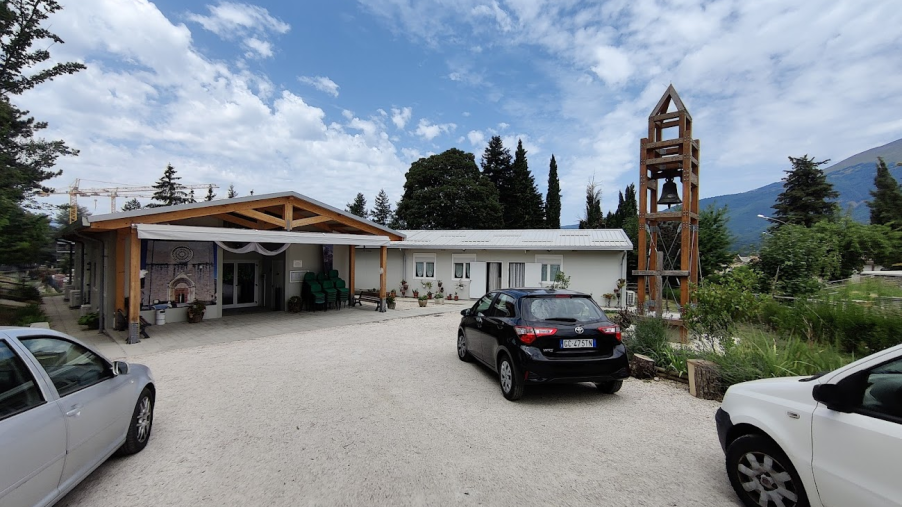
Amatrice: It was a magnitude 6.2 earthquake which occurred on the 24th August 2016. All 3 of the economic, social and environmental impacts occurred as a direct result of the quake. Plus, I was in the region when it happened… so I’ll always remember it vividly…
Case study: Amatrice - effects
Primary effects of the Amatrician earthquake included 299 deaths, 400 injured and over 4000 homeless. Most buildings in the town were severely damaged or completely destroyed, including the town’s school. As it struck during summer holiday season, the population of the town and surrounding areas was larger than usual as villas were occupied and tourists were about. The death toll includes several tourists from England and France who were celebrating local ‘festas’ at the time.
Pictures below are my own unless otherwise stated.
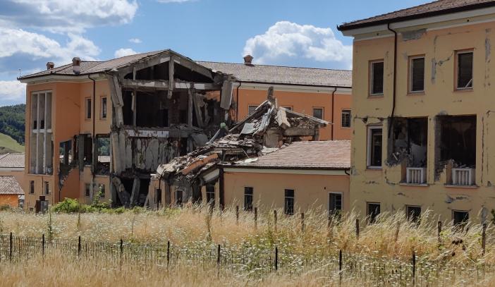
^^ A completely destroyed section of a building in Amatrice even 5 years later.
Secondary effects of an earthquake are things that happen as a result of the primary effects. In Amatrice, roads were blocked which reduced business and tourism in the area, farmers could not earn money as barns housing animals were destroyed and looting even occurred in the town, contributing to psychological damage among the residents.
As Italy is a very touristy country, to this day many tourists avoid the area as a result of the seismic activity.
Local ‘agritourismos’ said they were on the brink of closure as many tourists did not come to Italy the year after, and even two years later footfall in Umbria and Lazio was still much lower than before the quake.
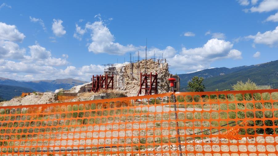
^^ Another home reduced to rubble
Case study: Amatrice - responses
Immediate responses are the responses to the impacts in the short-term, i.e a few days after the impact. In Amatrice, the army, Vigili del Fuoco (fire brigade) and dog teams arrived during the early morning to rescue people trapped under the rubble. The Italian PM Renzi announced a relief package of over 60 million euros for reconstruction work and tax subsidies for residents.
Unfortunately, immediate responses were not fully effective. Due to the mountainous terrain, many bridges were destroyed and landslides occurred, blocking access to the town.
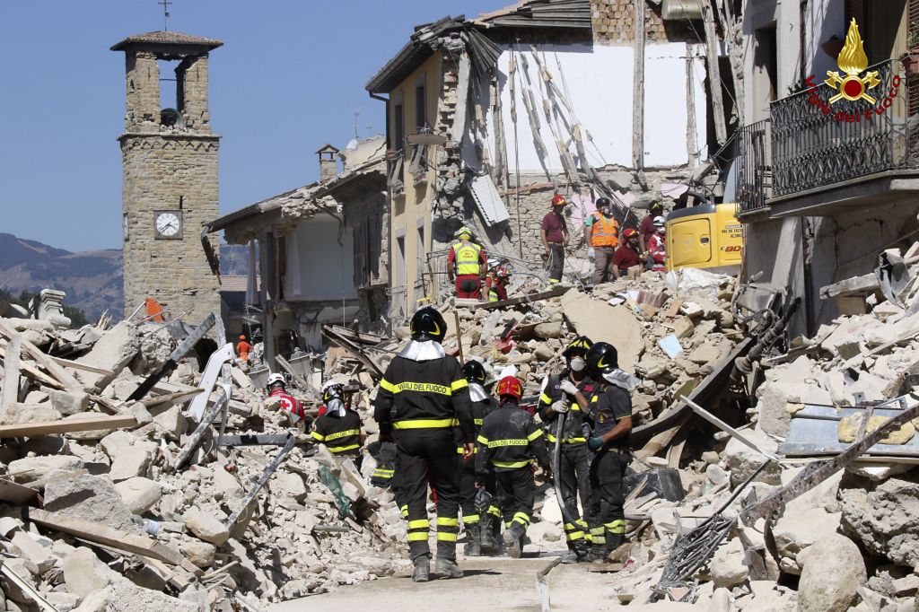
The rescue effort - the morning of August 25th 2016 (credit to AFP/FILIPPO MONTEFORTE)
Long-term responses are the those that go on for months and years after a disaster, usually in order to repair or reconstruct. At Amatrice, schools in neighbouring towns allowed Amatrician students in while several prefabricated classrooms were imported into Amatrice itself. After a year, the temporary camps that were set up transferred their citizens back to wooden houses in the town (see below pictures).
^^ New church and bell tower constructed later. Notice the anti-seismic material for the bell?
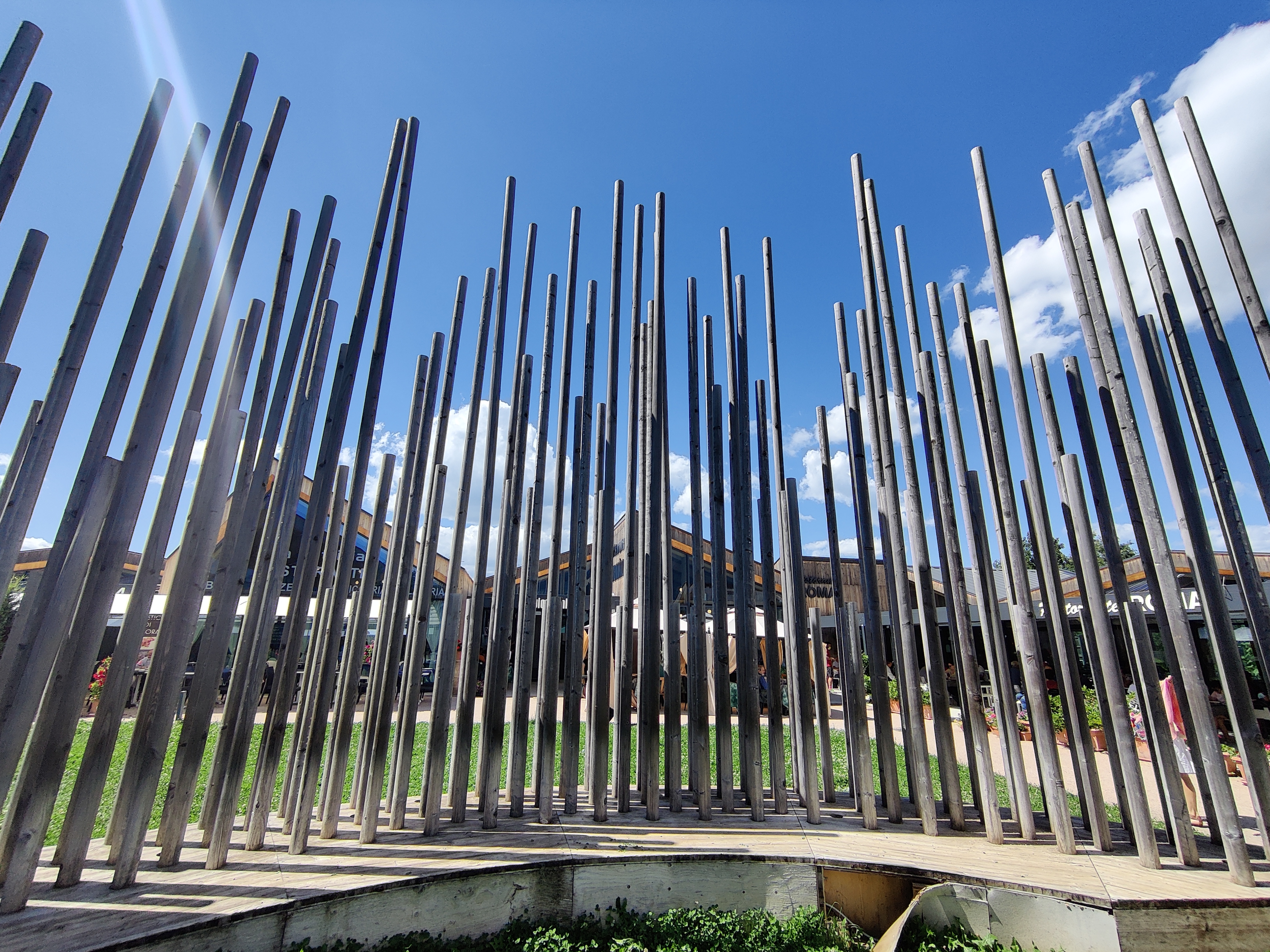
^^ The memorial, Ornamento della Piazza Dei Ristoranti, in central Amatrice. Built to remember these who lost their lives, the size of the wood represents the ages of the people.
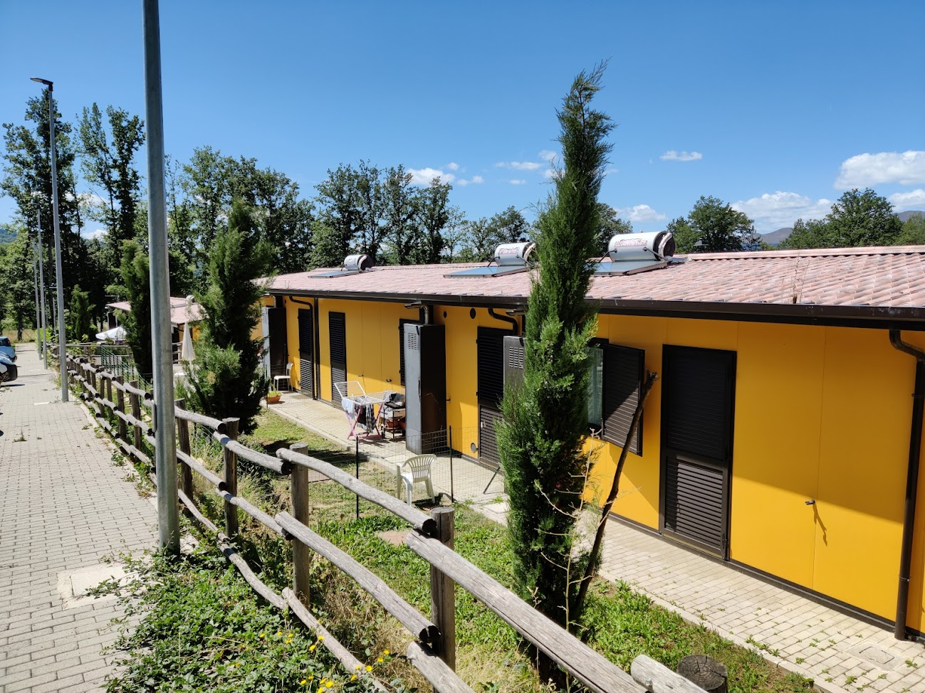
A row of little yellow wooden houses built as a result of the scheme. There were dozens of these homes in rows in and around the town.
Case study: Gorkha, Nepal
I have spent a lot of time on Amatrice so I will condense Gorkha a little bit.
In Gorkha, Nepal, on the 26th April 2015 a 7.8 magnitude earthquake hit. As the Richter scale is logarithmic, this means that the quake was 250 times stronger than Amatrice’s quake.
Primary effects included over 8,800 deaths, over 16,000 injured and a million homeless. Several dozen hospitals and schools were destroyed and historic buildings were damaged.
Secondary effects included an avalanche on Mount Everest, killing 19 more, and tourism decreased, resulting in less money for the locals who also suffered food shortages as the quake destroyed many silos and homes housing rice.
Immediate responses include temporary shelters set up by the UN and WHO along with medical supplies to avoid death water. However, like in Amatrice, the mountainous terrain made areas difficult to reach on foot so helicopters were used to bring aid to many residents.
Long-term responses included risk assessments and over 300 million US$ donated as aid to villagers. Tourist sites reopened a few months after the quake, including Everest.
Management strategies
People may continue to live in areas at risk from tectonic hazards because of a variety of reasons.
- Energy - in Iceland, much of the energy they generate comes from heat from volcanoes and hot magma - steam turns a turbine, etc etc (physics)
- Tourism - tourists love to spend time and money around volcanic sites, benefitting the locals and taxes for the government
- Farming - land around volcanoes is rich in nutrients. This can be used to produce desired products like Sicilian wine
Monitoring and predicting events using seismographs can be used to predict events and issue an early warning to residents. (This won’t work in LICs as they have no money)
Planning - shock absorbing foundations, large weights on the top of buildings to counteract shockwaves and having a local evacuation plan are effective methods at managing risks.
Weather hazards
(Date done in class: 6-16th October 2020)
Finally moving from tectonic! Sorry about that.

Global Atmospheric Circulation
Basically, the global atmospheric circulation model all depends on latitude
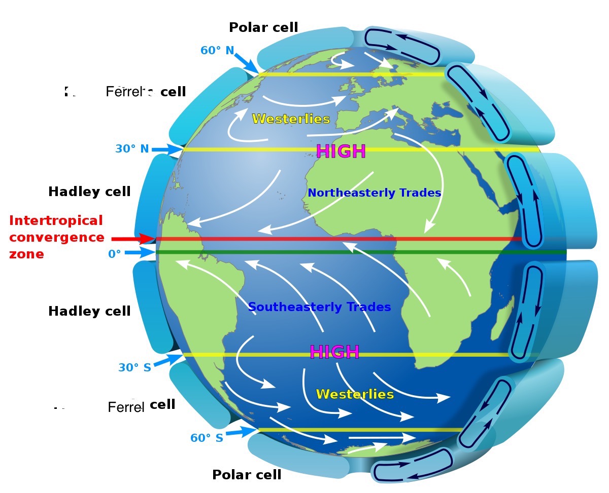
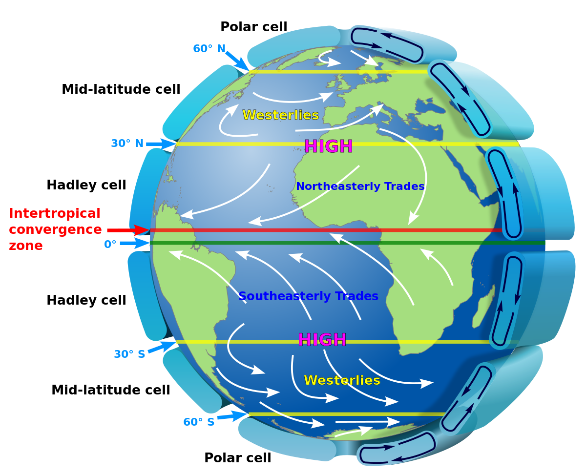
Low, High, Low, High (pressure)
ITCZ, Hadley, Ferrel, Polar (cells)
0, 30, 60, 90 (degrees)
Tropical Storms
Tropical storms develop:
- between 5-30 degrees N and S (low coriolis effect)
- above a 27 degree ocean surface temperature
- sea depth of 6o to 70 metres
- with low wind shear (wind speeds remain constant with height for clouds)
- between the summer and autumn
These tropical storms form when warm air rises to create an area of low pressure. As the warm air reaches high altitudes, powerful winds spiral around a calm central point, and the warm air then condenses and cools into heavy rain and thunderstorms.
With climate change, a warmer atmosphere means the it can hold more moisture, increasing the frequency of heavy rainfall. Storm surges will become higher due to thermal expansion.
Case study: Hurricane Sandy (2012)
Formed on October 22 (my birthday!), 2012 in the Caribbean sea and dissipated on November 2nd. At its peak, it was a category 3 hurricane as it hit Cuba on Oct 25th, and weakened down to a tropical storm 2 says later. However, it restrengthened slightly, and as it moved onshore in New Jersey it caused a lot of damage:
Primary effects: 72 deaths, 65 billion dollars in damages, flooded the coast, removed forest and coastal habitats, 12ft storm surge (death water!) and destroyed 650,000 homes in New York and New Jersey.
Like with tectonic hazards, better monitoring and predictions will result in people having more time to evacuate.
Case study: Storm Desmond & Eva (2015)
If you remember, Storm Desmond happened in December 2015. This was our UK recent extreme weather event. It was caused by 3 major reasons:
- Strong low pressure, or depression, this brought heavy rainfall and can also trigger a storm surge
- Weather fronts hitting areas of high relief caused high levels of orographic rainfall as water vapour was forced over mountains, which gets cooler as they go up, causing water to condensate and produce lots of rain (this was in Cumbria)
- Ground already saturated forced water to sit on top of it, causing floods, as it cannot be absorbed - the ground acts as a sponge.
The impacts of this, like in any natural hazard, are broken up into 3 categories:
- Social - hundreds of families were unable to return home for 2 years. Stress of the people affected by the floods was high as whole homes were flooded, resulting in life changing losses. Electrical substations were submerged also, so messages could not be sent to friends and family alerting for safety - potentially causing distress
- Economic - flooded farms damaged farmers’ income and resulted in higher prices due to lower supply. Businesses and warehouses were also destroyed, so essential supplies could not reach businesses. When businesses close, people lose their source of income as well.
- Environmental - hundreds of bridges destroyed, and rivers burst their banks in major towns and cities such as Carlisle.
Mitigation strategies have been employed to reduce the risk of these floods. These include improved flood defences - embankments were raised by over a meter along major rivers, and financial relief was provided to every flooded home. Despite new million-pound defences being built 6 years before, the Environment Agency’s plans were outdates. As a result of this, the agency have improved their alert system and can now send text messages directly to residents’ phones in case of a hazard.
“Evidence that weather is becoming more extreme in the UK” ok I’ll explain below
Climate change
(Date done in class: 10th November 2020)
I know this might come as a shock, but climate change is indeed real…
There is a lot of evidence for climate change. Starting from the longest time ago:
- Data from ice cores in the Antarctic can be analysed. CO2 and CH4 are emitted when this ice is melted and can be used to estimate atmospheric temperature and levels up to 800,000 years ago.
- Tree rings and fossils can also be used to estimate the climate.
- In the Middle Ages, the Thames froze a few times, suggesting winters were much cooler.
- The Met Office has had reliable data from weather balloons and satellites for over 100 years, documenting a 1 degree increase in average temperatures.
- Glacier retreat - melting when it’s warmer
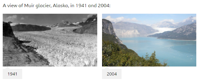
How much has changed in 60 years…
Causes of climate change
… include natural and human contributions.
Possible natural causes:
- Eccentricity (orbital change) - the Earth’s orbit changes to be an oval shape, lasting from 10 to 100 thousand years, changing the heating of the Earth.
- Solar activity - increase activity (solar flares) mean the Earth gets hotter
- Volcanic eruptions - larger eruptions can eject large volumes of ash, reflecting irradiating sunlight, making Earth cooler
- Milankovitch cycles - when all of the above come together to make an extremely cold or hot phase
Possible human causes:
- Fossil fuels - do I need to say anything else?
- Deforestation - forests act as a carbon sink, clearing forests for livestock, accessing remote areas, using raw materials, urban expansion, photosynthesis…
Effects:
- More extreme weather events - more rainfall, thunderstorms, hurricanes. Also more severe droughts - crops failing
- Sea level rise - ‘climate refugees’, increased flood risk
- Less money - lower yields, tourist areas like the Alps get less footfall.
- Glaciers retreat, putting additional water in the area’s drainage basin, increasing flood risk in the areas and risk of overwhelming water treatment facilities.
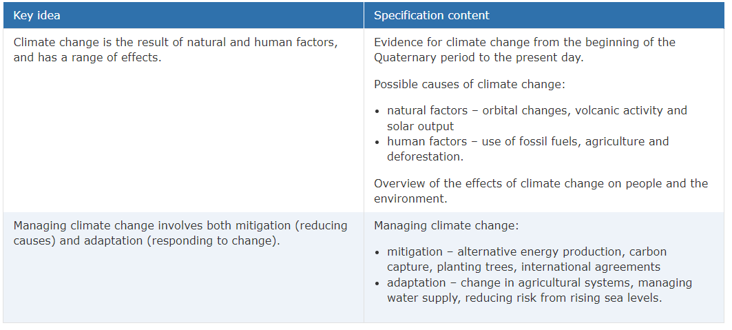
Managing climate change
… involves both
- mitigation (reducing causes) - solar power, renewables, GM food, insulation, carbon capture
- adaptation (responding to change) - increasing flood defences - drought resistant crops, building houses on stilts
I would summarise that if I had enough time, okay?!
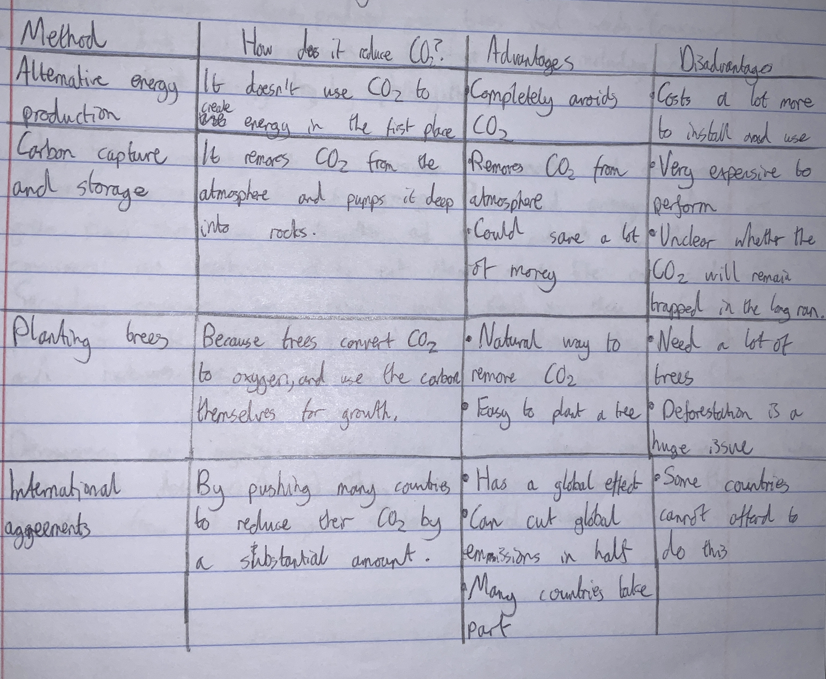
Several methods can be employed to reduce CO₂ from the atmosphere, with their own distinct advantages and disadvantages.
Section B: The living world
Section B is slightly smaller than section A by 3 marks
“In this section, students are required to study Ecosystems, Tropical rainforests and one from Hot deserts or Cold environments.”
translation: we do everything apart from cold stuff
Ecosystems
(Date done in class: 24th November 2020)
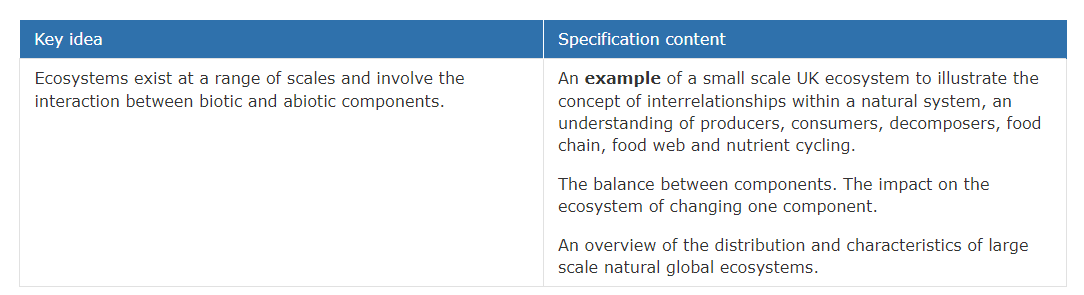
An ecosystem is made up of biotic (living - animals, plants) and abiotic (non-living - rocks, soil, climate) factors. It is a community of plants and animals which interact with each other and their physical environment.
Can be local (pond), regional (the Broads), and global (Sahara Desert)
Producers include algae, pondweed and grass. They absorb energy by photosynthesis. Consumers are creatures which eat herbivores (or plant matter), which eat producers. Secondary consumers are carnivores who will feed on these herbivores or consumers, like foxes or cats. Tertiary consumers are the top, or apex predators, and are usually the fastest and largest like lions or wolves.
Decomposers are organisms which break down dead organic matter. They return nutrients to the soil as a substance called humus.
Case study: Epping Forest (Essex)
Epping Forest has bogs and ponds which have their own unique species, including 20 kinds of dragonflies.
Characteristics of Epping Forest’s ecosystem include a wide variety of tree species, oak, elm, ash, beech. On top of this, there are many producers, insects, mammals and birds, including amphibians and reptiles. 700 fungi species act as decomposers.
The ecosystem interdependent as the forest’s producers, consumers and decomposers rely on each other. This is seen when the deciduous trees lose leaves to maximise photosynthesis to conserver energy. Decomposers and detritivores quickly convert this materal into humus by the end of Autumn. This helps the new season’s plant growth.
Visitors to the forest pick berries and flowers, and in doing so spread seeds. Previously, the trees were cut back to encourage new growth. The biomass store is large due to big trees, and the soil store is large due to lots of humus.
Ecosystem balance example: Yellowstone
In Yellowstone National Park (Wyoming, USA) before 1995, the ecosystem was balanced. However, wolves were reintroduced in 1995, and this caused a 50% drop in the elk population there. This changed the physical environment as well, as these elk no longer grazed on the tree leaves, resulting in more tree cover and stronger trees.
Because of this, beavers rediscovered a more abundant food source that hadn’t been there earlier, allowing them spread and construct new dams and ponds, affecting the physical landscape and hydrology!
Source: Wolf Reintroduction Changes Ecosystem in Yellowstone (very good read!)
Tropical rainforests
(Date done in class: ~12th December 2020)
There are two main characteristics of tropical rainforests - the climate and vegetation.
Their climate is warm and wet, as they are located on or near the equator. Annual temperatures average 26ºC and has little variation, no matter the season. Their annual rainfall typically is above 2,500mm, allowing a wide variety of vegetation to be supported, alongside their huge rivers.
There vegetation of tropical rainforests is extremely biodiverse, including trees over 30 metres in height.
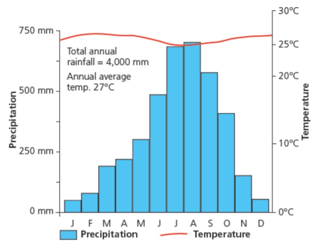
Precipitation and temperature in Duala, Camerooon.
Soils, climate and interdependence
In the tropical rainforest, soils are very poor and infertile. This is because there is rapid nutrient cycling (transfer of nutrients between biomass stores). The nutrients are quickly recycled whenever it enters the soil store and is absorbed by the vegetation. Most of the nutrients are stored in the biomass (living plants and animals) and also the litter (dead wood, leaves and other plant/animal remains) on the ground, which become part of the soil after decomposers or detritivores process it. Plants uptake these nutrients dissolved in the soil (Biology revision useful here!) or is lost by nutrient leaching When these plants die, then nutrients are placed back into the soil, and so on. This shows the rainforest’s interdependence.
As the conditions are very warm all the time, the litter decomposes very quickly, and the rain which reaches the floor often washes these little nutrients away (into its rivers or tributaries). However, there is still enough for the ecosystem to support itself.
The 3 main reasons for growth can be summarised into:
- Rapid nutrient cycling - encourages loads of growth in small areas;
- High intensity of sunlight - high levels of photosynthesis;
- Warm and humid environment - great for plant growth all year.
Organisms’ adaptations
Plant adaptations
Everything in the rainforest has been adapted to the hot and humid environment. The easiest way to explain this is in the trees and plants.
For example, lianas are parasitic vines that have roots in the ground but climb up the trees to reach light. Their leaves and flowers grow in the canopy.
Tree trunks in the rainforests are mostly tall and thin to maximise the energy expended into travelling upwards and into the sunlight.
Trees’ bark is also very smooth to allow quick runoff into the roots (stem flow). Trees may also have ‘drip tips’ which allows water to run off them (drip flow), resulting in less damage. Their cuticles are also thicker, making them very waxy, and their stems are flexible to maximise rotation to point at the sun for maximum photosynthesis!
Finally, buttress roots are big, ridged roots with a huge surface area which significantly supports the larger trees (ususally emergents - above canopy)
Epiphytes are smaller plants which live on other plants’ branches in the canopy, getting all their nutrients from the air and water. This is possible as the canopy acts as an umbrella - moisture evaporating from below gets trapped in it, and moisture from above (i.e rain) gets trapped in it as well. More like a sponge now I think about it! Evapotranspiration (from evaporation and transpiration - from the plants) is also strong, increasing atmospheric moisture levels, which will eventually fall back down as precipitation.

Drip tips
Animal adaptations
Of course, animals have adapted in some cool ways too.
- The sloth moves slowly to make it hard for predators to spot, and also camouflages among the trees.
- Frogs can only hear their own species’ chords.
- Flying frogs have flappy bits and loose skin between its limbs to stretch it out, allowing gliding between plants.
- Toucans and parrots have large and strong beaks to crack open and cut fruits and nuts, and grab these from weaker branches.
Bright colours are also used among animals to act as a warning against predators, for example in poison dart frogs.
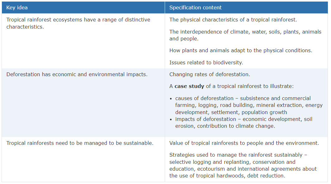
Biodiversity issues & deforestation
Tropical rainfowests have the highest levels of biodiversity in any biome :)
BUT WE MUST NOT DISTURB THEM! (or, at least, we can disturb them, but in much more friendly way)
Human exploitation is destroying much of the rainforests’ biodiverse species, endangering them. Logging and commercial farming result in large swathes of the rainforest being unsustainably cleared for cattle farming and cash crops like palm oil, soybeans, or mahogany trees. Hydroelectric power dams have resulted in large areas being flooded. Subsistence farming has also contributed to deforestation as well, thanks to the increasing population in these areas in settlements.
Look at this logging activity on Google Maps
Case study: The Amazon Rainforest
I could not find my notes on the rainforest but there’s so much info online and in books there’s no point even looking for them.
Useful resources: https://www.coolgeography.co.uk/gcsen/Amazon_Case_study.php.
Causes of deforestation:
- Subsistence farming - clear forest and burn it, growing crops until the soil is exhausted, repeat.
- Commercial farming - to sell produce to big retailers.
Hot deserts
(Date done in class: 8th-22nd January 2021)
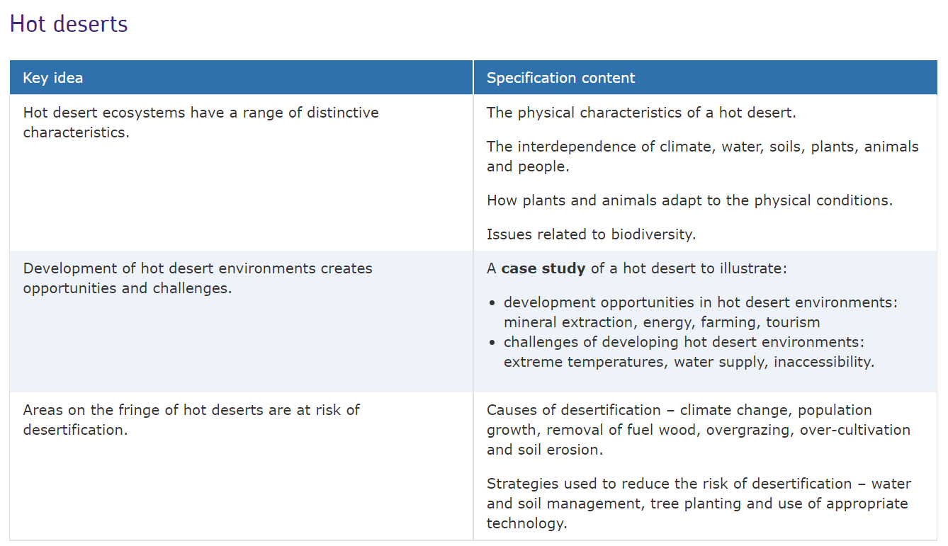
A hot desert is a place which receives less than 250mm of annual rainfall. This aridity controls the life in the desert.
The Sahara Desert has large sand dunes, up to 150 metres. On the border of these arid areas, there are semi-arid areas, or areas on the desert fringe. For example, in Africa, there is the Sahel.
There is a wide variety of biotic and abiotic components in hot deserts. Abiotic parts includes soil rocks and water and biotic animals and organisms play an important part in maintaining a healthy environment. For example, vegetation roots stabilise sandy soils in semi-arid areas and stop soil being blown away by the winds. Plants extract nutrients from the soil and return them when they died, showing the dependence of both abiotic and biotic components on each other.
Plants that can survive in dry conditions are called xerophytes. They have thick waxy cuticles and do not have many leaves which transpire, which minimises water loss. Many plants have most of their biomass example their roots below the ground to cool them down and further reduce water loss.
Cacti have spines which make it difficult for predators to eat them. They store water in their tissues making them known as succulents. Desert flowers have seeds which can germinate after heavy rain - they can lie dormant for many years. Their life cycles can complete in under a month and produce brightly coloured flowers and petals to attract insects. They are known as ephemerals.
Case study: the Western Desert
The Western Desert covers 200,000 square kilometres. Development in the Western Desert has increased significantly in the past century or so, with Las Vegas (NV) and Phoenix (AZ) home to several million residents, and act as extremely popular tourist destinations for international travelers. In more arid areas, the population density is sparse, allowing developments. These include:
Farming
Large aquifers are located below some of these regions. As these are generally located above a layer of permeable rock, over the years rainwater becomes trapped, and this can be obtained by using wells. As desert regions have high temperature and sunlight intensity due to their perpendicularity to the Sun, farming is very fast and yields are high, providing that water can be located. As well as wells, canals have also been created to divert large amounts of water to these regions. Farmers make up 10% of Colorado’s economy, but are allocated 80% of state water. California’s deserts produce tonnes of lush vegetables, lemons, peppers and grapes - for wine, which is the exported.
Mineral extraction
Rare earth elements, used in the manufacturing of goods (especially technology) are found in high concentrations in the Western Desert. Around the Grand Canyon, a plan was created for the creation of a uranium mine in 2012, but local people campaigning stopped this development, due to radioactivity and contamination concerns. Copper mining has also increased in popularity, at a detriment to the environment.
Energy production
Due to the strong solar availability in desert regions, the Western Desert has an abundance of current and planned solar farms, for example in the Sonoran Desert there will be enough energy from solar cells to power 100,000 homes. During construction and maintenance, this will create jobs and income for workers. Furthermore, there are large oil reserves below the Western Desert, as well as other fossil fuels like coal - a 50 million $ a year industry. Hydroelectric power is also used, with the Hoover Dam employing > 5000 people in the 1930s.
Tourism
The Grand Canyon is a popular tourist destination, due to its natural, wild landscape offering spectacular views - at least, that’s what people say. The two major lakes, Lake Mead and Lake Powell attract millions of visitors anually, and offer a variety of water sports. Of course, Las Vegas is another hugely popular resort, attracting up to 40 million visitors a year!
Challenges: Accessibility
The low population density means that infrastructure has less incentive to be developed. For example, roads are not always the best quality, which hinders the ability for people or businesses to move around. This then means that people and businesses cannot easily make money. There is also a safety issue in regards to the roads - in 2015 a man had died after becoming lost off-road, and ended up eating by coyotes. This also puts people off moving to the area, which in itself would bring money to the area
Challenges: The water crisis
Migrants in the 19th and 20th century (lucky ocr history people, I’m jealous) adapted to these challenges by having flat roofs on their houses to collect the little amount of rainwater, had small buildings in general with little windows to reduce temperatures and sunlight penetration, had whitewashed walls to reflect more sunlight instead of absorbing it, and wore wide brimmed hats to keep people cool. Now, extreme weather is less of an issue due to an increased reliance on air conditioning, and the improved water supplies.
The temperatures in the Western Desert reach uninhabitable levels frequently - Death Valley reaches 50ºC in summer, and this is becoming more frequent with climate change. Of course, deserts aren’t exactly known for their water either, with water levels in Lake Mead reaching record low levels, partly due to the increase of population in surrounding regions - over 30 million depend in the Colorado River’s water.
Case study: the Sahel
The Sahel isn’t an official ‘case study’ - as in it’s not required to learn in the specification. But, you need to know about them.
Desertification is the process where fertile land becomes desert. Over 1 billion people worldwide are threatened by this, as their habitable desert fringe areas are turning into hot desert areas.
Causes of desertification
-
Climate change. Scientists do not know whether climate change caused by humans will exaggerate rainfall amounts, and are even less confident at predicting rainfall distribution. Some even say that climate change may lead to the ‘greening’ of the Sahel with more water vapour in the atmosphere from the heating of the oceans, but it may just result in sand dunes spreading over arable farmland.
-
Population growth. Since 1950, the Sahel’s population has over tripled to 100 million, fuelled by high birth rates and longer life expectancies. Refugees from conflict areas, such as in Sudan, has contributed to this. Desertification caused by population growth in one region will often result in people being displaced to other fragile areas, acting as a catalyst for desertification there!
-
Removal of fuel wood. Vegetation is used as fuel in many poorer countries, and acts as an essential source of fuel to cooking and cleaning water which rural settlements rely on. On top of this, there is not enough money for infrastructure like gas pipelines or electricity pylons to be implemented, and even if they were erected then rural villagers may not have enough money to afford them. When large areas of vegetation are removed, the soil is unprotected and prone to wind or water erosion, increasing desertification.
-
Overgrazing. More animals = less vegetation. Too many animals = irreplaceable vegetation (can’t regrow). Geopolitical boundaries, civil war, political instability and land deeds by large companies force farmers with animals to remain in one location for extended periods of time.
-
Over-cultivation. Continually farming land reduces its fertility. Combined with population growth, which has resulted in more mouths to feed, subsistence agriculture has increased, draining the little amounts of water stabilising the environment. Cash crops are also grown in these desert fringe areas by commercial farmers, which significantly accelerate the draining of water in aquifers.
Any of the above leads to soil erosion. Firstly, the exposed topsoil is baked by the intense sunlight. Then, when either intense yet infrequent rainfall arrives or high winds hit the area, it washes the topsoil away instead of it being absorbed, making the soil unable to grow vegetation.
Strategies to reduce the risk of desertification
-
Water and soil management. The idea of land management is that it improves the soil quality, so water is held within the soil to stop it being vulnerable to being blown or washed away. Ideas include planting grass (especially on slopes) to keep the soil in place. Low stone walls or bunds have been employed in Mali and Burkina Faso every 10-25m in some areas to stop soil eroding - it may be moved, but not moved far! When water builds up behind a bund (puddle) this gives the water time to soak into the ground, which also helps reduce the chance of the top soil being removed.
-
Tree planting. Tree roots help stabilise the soil. When leaves decompose, they replenish nutrients, helping more plants and their roots grow. The Great Green Wall (France 24 YouTube vid) is a great expanse of trees over 8,000km and almost 12 million hectares of reforestation, ameliorating land in the Sahel at risk from desertification, across several African countries. As it will also rely on cooperation between different countries it is hoped that it will reduce conflict, which in itself can cause degradation of the land. It will help stabilise the soil, and also employ people to bring sustainable development into these regions, and including poorer communities.
-
Use of appropriate technology. Efficient stoves significantly reduce the amount of wood and charcoal being burned, and use more local resources to cook food. They can also include a thermocouple, which can charge a mobile phone, allowing farmers to access weather forecasts. Very smart IMO.
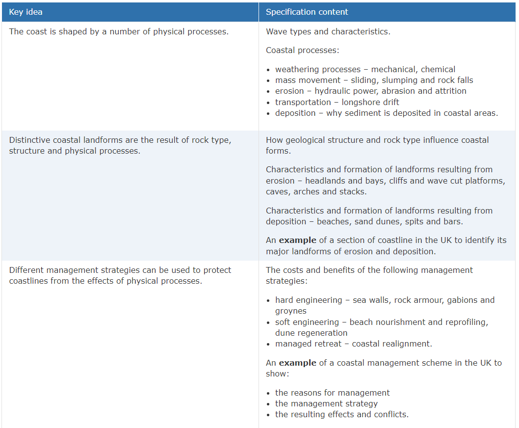
Section C: Physical landscapes in the UK
ayyy section C, now we’re 67% through the paper! I believe this section is the shortest. there were ~6000 words in the above 2 sections. let’s see how quickly I can summarise this section, it won’t be as detailed as the previous two. mainly because my exam is in less than 2 days but shh
UK physical landscapes
The UK’s main upland areas are in Scotland, northern England and Wales. Scottish mountains are steep and glaciated. The Cumbrian Mountains in northern England are home to the Lake District. The Cambrian Mountains in Wales are the source of the River Severn.
Lowland areas include East Anglia and the Fens - many areas are below sea level. Northeast England has a huge river system which drains into the Humber.
The key to this is remembering the northwest/southeast divide
Coastal landscapes
There are two types of waves: constructive and destructive. Waves start at sea, as it approaches the shore, friction slows the base of the wave resulting in that wave’s motion becoming elliptical. This continues until the top of the week breaks over on the shoreline.
Constructive waves have a longer wavelength and a shower wave truth or amplitude. This results in the build up if beach material through deposition, with a high wash and weak backwash, and the angle of the wave is also quite shallow.
On the contrary, destructive waves have a short wavelength meaning they have a high frequency. They have a big amplitude along with a steep wave angle. This results in a strong backwash and a weak swash, resulting in beach material being removed.
Some useful things:
- The fetch is the distance of sea wind has travelled over before reaching land.
- Stronger winds = stronger waves as more energy has gone into the waves
- Constructive waves are found in bays, which are more sheltered, and create sandy beaches. Transports sand and sediment up the beach.
- Destructive waves are found in exposed areas, including exposed bays, where pebbled beaches are built up. Can erode headlands. More common in winters. Take back beach material into the sea.
- Water molecules in deeper water move in a circular motion, but in shallow water, due to the friction, the water itself moves towards the beach.
Coastal processes
Chemical weathering is boring so I won’t write much about it. It occurs when a chemical reaction happens when water meets rock. For example, acidic rainwater reacts with limestone to form a soluble substance, so it is moved, usually into the sea, never to be seen again. lmao
Mechanical weathering includes freeze-thaw, where water enters cracks, expand when freezing overnight, putting pressure on the rock with the crack in, and this is continued many times. Salt weathering also does this to an extent by crystallising and evaporating on exposed rock.
The load is transported material.
- Mass movement – the downhill movement of sediment because of gravity. Includes:
- sliding (large clumps of rock slide down)
- slumping (see below)
- rock falls (parts of the rock fall from the cliff face - usually by freeze-thaw weathering)
- Erosion (wearing away of rock at the coast). Because of destructive waves
- Hydraulic power is the sheer force of the waves pounding against the cliff. It compresses air inside cracks and when the wave retreats, this pressure is released, creating almost an explosion.
- Abrasion is when the waves throw sediment like sand against the cliff, scratching it. This is usually most prominent between the high and low water marks.
- Attrition is the grinding down of particles in the water. As load particles hit each other, they wear away the jagged edges of rocks, for example, to become smaller and smoother. Sometimes weaker rocks can be smashed into several parts.
- Transportation - the larger the load particle, the greater strength is needed for it to be transported by the water. The smaller load particles are carried in suspension, whereas heavier load particles, usually on the seabed, are moved through traction.
- Longshore drift is when load is transported along the shoreline. The prevailing wind determines its direction. In the UK, there are eleven sediment cells which determine the overall direction of longshore drift in those cells. The swash occurs in the direction of the prevailing wind. Then, due to gravity, the deposited sediment is dragged back into the sea at right angles to the shore. It is carried easterly in a zig-zag pattern. /| /| /| /| <- (10/10 diagram)
- Deposition - when waves leave behind the load they were transporting, called sediment. Deposition results in more sediment remaining on the beach, than is taken away by waves’ backwash. It will happen:
- in sheltered bays, with low energy, constructive waves dominating
- if there is large amounts of erosion happening, more load is available
- if the beach is flat and large - backwash not strong enough as wave is weaker
- if sediment is trapped behind a spit when the tide is going down
- if a structure is blocking the transportation of sediment (groynes)
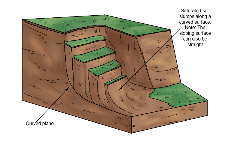
Slumpy…
Case study: the Dorset coastline
^^ Middle click above to open google maps in a new tab with this area of coastline! ^^
Bays and headlands are formed when there is a discordant coastline. This is when layers of alternating rock parallel to the coast exists. The softer rock (clay) is eroded before the harder rock (limestone, chalk).
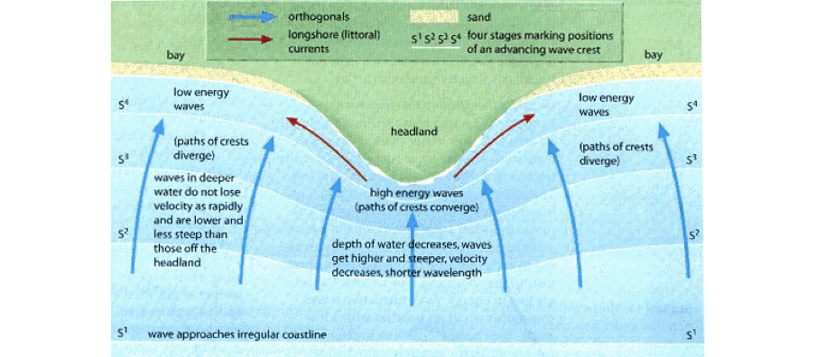
Wave refraction at a headland.
Coves are formed wenn the hard rock, limestone in Dorset, is broken, allowing the water to more easily erode the rocks behind it. Example: Lulworth Cove. Drag and pan while holding the control key to go 3D, you can see some cool formations.
Cliffs in Dorset are mostly made of limestone, chalk, sandstone and chale. Soft cliff rocks are more prone to slumping, and hard rocks result in large, tall cliffs and wave cut platforms.
A wave cut platform is an area of bedrock visible at low tode. It slopes gently into the sea, and is covered by the water at high tide. The stages of a cliffs and wave cut platforms are below:
- The land slopes into the sea, and being weakened by weathering processes.
- Waves erode the base of this with hydraulic power and abrasion between the high and low tides
- Continued erosion causes the rock to break away. It now has a ‘notch’ at its base. The rock above the notch is unsupported and prone to falling down.
- Continued erosion results in the overhanging cliff falling into the sea as the notch is so big. This step drop is called a cliff.
- The cliff retreats into the land when this process is continued.
- The old base of this cliff is left as a wave cut platform, and can become smoothed by traction or saltation occurring on it.
Caves, arches, stacks and stumps occur generally at headlands.
- Caves may be several metres high at their entrance. Usually found in hard rocks (limestone).
- Arches are unsupported at the top, and act as an extension of the headland. The arch is wide at the base as there is usually a wave cut notch supporting it.
- Stacks are physically detached pieces of rock from a headland. Several metres high, continually being weakened by sub-aerial processes and erosion from the sea,
- Stumps are the bases of collapsed stacks, for example Old Harry’s Wife. They are usually submerged and only visible at low tide.
Old Harry is an example of crack -> cave -> arch -> stack -> stump.
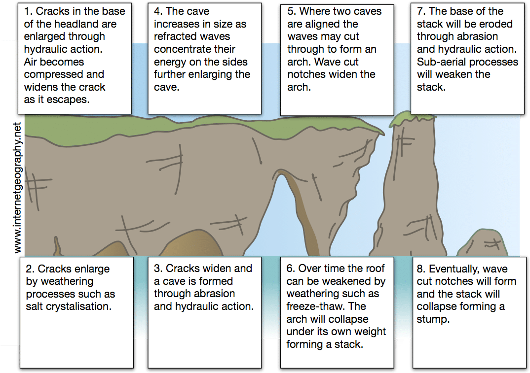
Diagram of a crack, cave, arch, stack, stump, and processes
Coastal depositional landforms
I have already explained how beaches are formed, so I’ll skip that here.
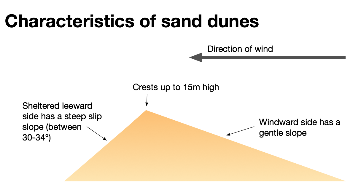
Sand dunes
Sand dunes are formed mostly (95%) through saltation, where grains of sand are picked up by the wind and bounce along the beach. When an obstacle is reached, like driftwood, the grains of sand will settle, forming a small ridge. This ridge will gradually increase in size, and on the leeward side (opposite the windward size where the wind is blowing) the dune will collapse, creating a steep gradient.
Easier to visualise.
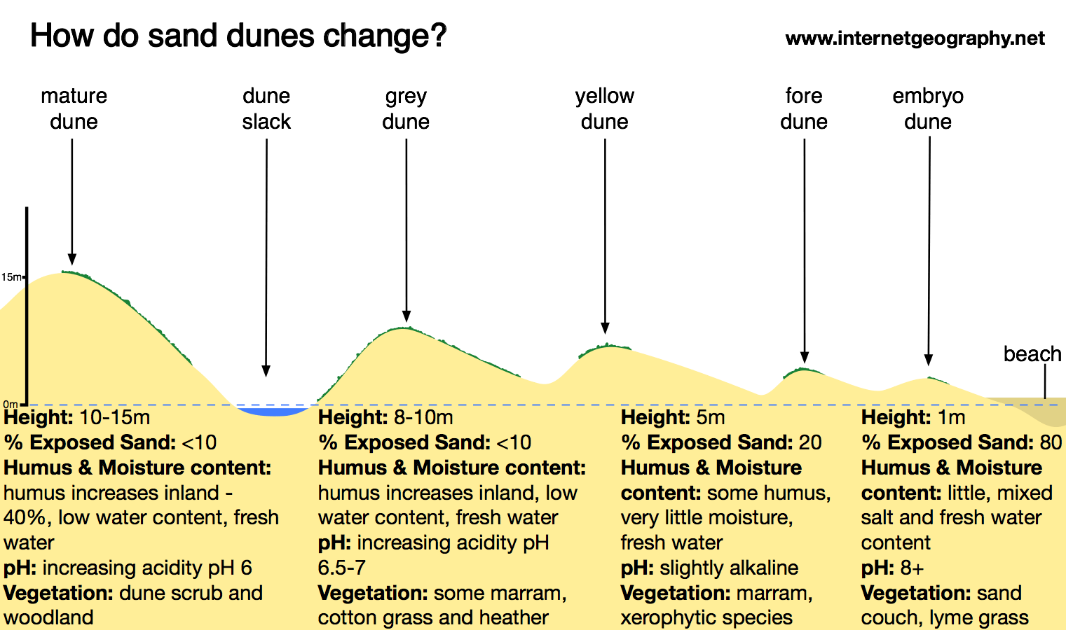
The further inland the dune, the taller and more vegetated it will be. Dunes close to the beach are ‘embryo dunes’ - they look yellow and are small. Marram grass and vegetation bind sand together inland, and ‘mature dunes’ even have trees growing on them, and look less like sand and more like dirt.
Cheeky dune pic
Spits
When a coastline changes shape (i.e moves inwards), a lot of deposition happens, resulting in the beach growing out into the sea. The prevailing wind and longshore drift make this happen. The depositional material gets smaller as the spit increases in length due to attrition. A dominant wind will cause the spit to form a ‘hook’ (recurve) inland. Over time, there will be multiple hooks and, in Dorset, there is a spit which is 4km long.
A salt marsh and lagoon will form behind the spit which is sheltered from the waves, over time this will become vegetated.
Bars
A bar is a ridge of sand separating a bay from the sea. Longshore drift transports sediment from one side of it to another. They can be submerged as well.
Coastal management strategies
Various strategies can be employed to protect coastlines from the effects of physical processes.
Hard engineering:
- Sea walls - last many years, gives residents a sense of security, do not have an impact on other areas of coastline as they do not interfere with sediment. However, they can cost £5000 per metre making them the most expensive, and restrict access to the sea. They also look ugly!
- Rock armour - only £2000 per metre, cheaper than sea walls. Quick and easy to build and maintain. Can be placed in a variety of areas, in front of sea wall, or sand dune. However, hazardous for people navigating around/over them (slippery), they look ugly and need regular maintenance as storms can move the rocks. They also are imported from Scandinavian countries usually.
- Groynes - cheap - £5000 each. Quick and easy to build and maintain. Lasts decades if looked after. Larger beach, so boosts tourism and local economy. However, they are ugly, restrict the supply of sediment elsewhere on the coastline and are very dangerous with shallow water on one side and deep water on another.
- Gabions are basically rock cages using local pebbles, which are very cheap and easy to construct (£100/metre). However their metal casing could be a hazard after they break, lasting 20 years.
Soft engineering:
- Beach nourishment is when lost sediment is placed back on the beach. It blends in with the environment and reduces future erosion as more wave energy is dissipated across the beach. It also allows beaches to be larger, attracting more visitors and increasing tourism. However, dredgers are expensive, like several hundred thousand, and the sediment costs millions.
- Beach reprofiling is the reshaping of a beach using existing material. For example in Seaford, Sussex, shingle is moved back up the beach after winter storms.
- Sand dune regeneration is the creation of new or the amelioration of existing sand dunes. They protect the land from the sea as they are like a barrier. However, it takes years for grass planted to spread and for the dune to mature. During maturation, they are often fenced off and cannot be walked on. There is also no guarantee that they will stay in the same place. Won’t really stop strong waves eroding, either.
- Managed retreat is when areas of land is allowed to be flooded. People are moved out and buildings demolished, and farmland flooded when a breach is made. There are obvious benefits and disadvantages, I won’t explain them.
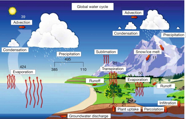
River landscapes
As the river moves from the upper course, through the middle course and into the lower course, its cross profile changes. In the upper course, hydraulic action results in high amounts of vertical erosion happening, making the valley deeper and steeper in areas of high relief. The little energy the river has is used to overcome the friction to deepen its channel.
The long profile shows the gradient of the river changing from the source, in mountainous areas, to the mouth, in the sea.
-
Abrasion is when small rocks wear down the riverbanks and bed, wearing it down. It increases vertical and lateral erosion.
-
Attrition is the same as it is in the sea - when jagged rocks smash into each other, making them smoother and smaller if the rock splits. The further the river progresses downstream, the smaller and smoother the rocks.
-
Solution is the dissolving of rocks like chalk and limestone. It is invisible in the water.
-
Suspension is held and carried within a river’s flow, including fine, light material like alluvium.
-
Saltation is when small stones are bounced along the riverbed, depending on the speed of the water flow.
-
Traction is when large rocks or even boulders are rolled along the riverbed, also known as bedload.
Rivers deposit sediment (called fluvial deposition) when the velocity of the river decreases. Larger rocks and boulders are the first to be deposited when the velocity decreases, as they require the most amount of energy to move.
Upper course
Erosion: Vertical erosion by hydraulic action.
Transport: Mostly traction moving load.
Deposition: Large boulders and big rocks being deposited
Long profile: Trickles merge into a larger channel, down a steep gradient. Waterfalls and rapids occur.
Middle course
Erosion: Less vertical erosion, more lateral. Attrition and abrasion common.
Transport: Suspension, less traction.
Deposition: Increased levels, especially on meander bends where there is high friction.
Long profile: Deeper channel, increased volume, gradient flattening.
Lower course
Erosion: Hydraulic action increases lateral erosion (sideways), as seen in meanders. Not much vertical erosion at all
Transport: Suspension and solution. High amounts.
Deposition: Fine material and alluvium deposited as the main fluvial process. More important than erosion
Long profile: Channel is at its widest, deepest, flattest. May be tidal. Brackish water.
How are V-shaped valleys formed? [4 marks]
V-shaped valleys are formed in upland areas. Streams are very small and have low discharge, while also having a large, angular bedload. Through gravity and traction, the dominant type of erosion is vertical, resulting in steep sides of the river channel, which are now unsupported. Through chemical weathering from rain, there may be a sudden mass movement of this loose material, sliding this rock and material into the river channel. This is repeated, and over time, a V-shaped cross-section is formed.
4/4 marks given.
Specification: The upper course has characteristics and formation of landforms resulting from erosion.
Interlocking spurs are formed in the upper course of the river. The geology in these areas is mostly hard rock like granite. Freeze-thaw weathering broadens out the valley channel. Repeated many times, rocks fall into the channel. These eroded obstacles are in the way of the river, which takes the quickest route which is on either side of these obstacles, or if there are areas of harder rock. Over time, this will result in the river channel bending around.
Waterfalls and gorges form in he upper course too.
- The soft rock below is eroded quicker than the hard rock above.
- As erosion continues, the hard rock is undercut forming an overhang.
- Abrasion and hydraulic action erode to create a plunge pool.
- Over time this gets bigger, increasing the size of the overhang until the hard rock is no longer supported and it collapses.
- This process continues and the waterfall retreats upstream.
- A steep-sided valley is left where the waterfall once was. This is called a gorge.
Specification: The middle course has characteristics and formation of landforms resulting from erosion, and deposition.
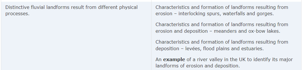
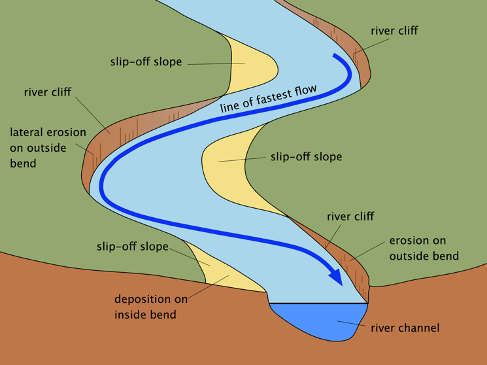
A meander is a bend in a river. Fast flowing water on the outside causes lateral erosion through abrasion and hydraulic action, forming a river cliff. Near it is the point at where the water is moving the fastest, the thalweg.
On the other side, sand and pebbles are deposited due to high friction, forming a slip-off slope. Water here is slow.
The corkscrew motion of the fastest flow of the water is helicoidal.
When an oxbow lake eventually evaporates, a ‘meander scar’ is left behind.
What’s actually happening, visualised.
Levées
Specification: The lower course has characteristics and formation of landforms resulting from deposition.
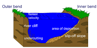
Levées are super cool in my opinion. They are naturally raised riverbanks found in the middle and lower courses. When the river floods, velocity is reduced and therefore sediment is deposited. The heavy stuff is deposited close to the river channel, being harder to transport; smaller stuff is deposited further away. Sometimes the levées get so high the river flows higher than the flood plain.
My beautiful levée…
Flood plains and estuaries
Flood plains are large expanses of flat, eroded land either side of a river prone to flooding. They are formed due to both erosion and deposition. Floodplains are often agricultural land, as the area is very fertile because it’s made up of alluvium (deposited silt from a river flood).
An estuary is where the river meets the sea. The river here is tidal and the water is brackish (a mixture of saltwater and freshwater); when the sea retreats the volume of the water in the estuary is reduced. When there is less water, the river deposits silt to form mudflats which are an important habitat for wildlife. A river delta is a triangular formation in the mouth of a river where sediment has been deposited. The River Severn’s estuary is 3.2km wide.
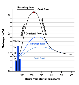
Flood hydrographs
There are a wide variety of reasons which affect flood risk.
With a little extra information, but most of it is useful to know.
Flood hydrographs are used to show the relationship between precipitation and discharge. On the x axis is the time, usually in hours. The average peak rainfall to peak discharge time is usually 12 hours.
On the y-axis is the discharge, measured in cubic meters per second (cumecs), of the river channel. A high peak flow with a short lag time is the worst scenario: there will be lots of flooding potential, and people will have little time to prepare for it.
Finally, the last section on paper 1.
Factors affecting flood risk:
- Prolonged rainfall - if it rains for a long time, the land can become saturated. If there is more rainfall it cannot be soaked up, it runs along the surface, increasing surface run-off. This results in water quickly being moved into the river channel, reducing lag times, as it cannot infiltrate into the land. The faster the water reaches the river, the more likely it is to flood.
- Heavy rainfall - if there is heavy rainfall there is less chance of it infiltrating the land, so it runs off into the river immediately.
- Relief - a steep valley is more likely to flood than a flatter valley because the rainfall will run off into the river more quickly, and it cannot be absorbed by the soil.
- Geology - permeable rocks allow water to pass through pores and cracks, whereas impermeable rocks do not. If a valley is made up of impermeable rocks, there is a higher chance of flooding as there is an increase in surface run-off.
- Vegetation - trees and plants absorb water, called interception. Lots of vegetation reduces flood risk. Deforestation will increase the flood risk, as the water cannot be intercepted and flow into the river.
- Urban land use - when an area surrounding a river is built on, the anount of impermeable surfaces increase, like concrete and tarmac. Drains and sewers take water directly into the river channel, increasing flood risk.
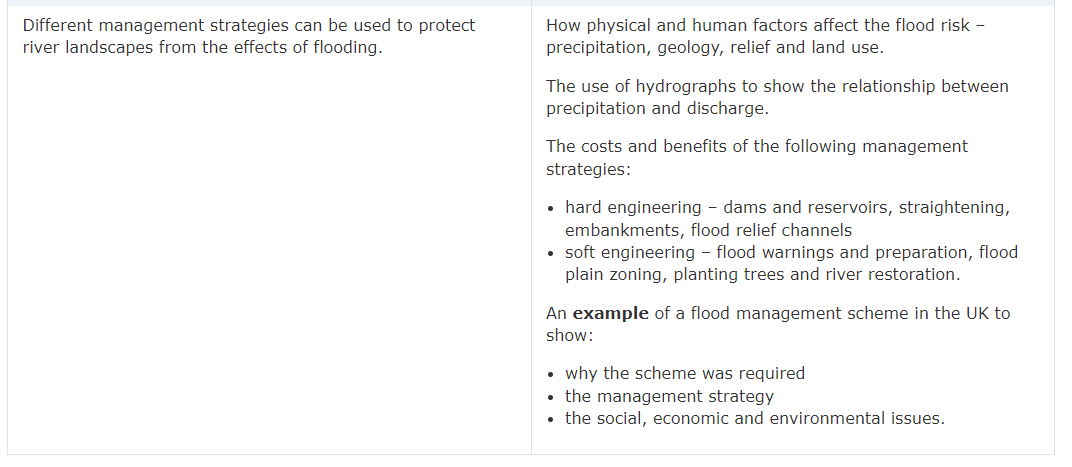
River management strategies
Finally, the last section on paper 1.
Hard engineering
Involves building artificial structures which try to control rivers.
-
Dams and reservoirs - the dam traps water, which builds up behind it, forming a reservoir. Water can be released in a controlled way. Can be used to produce electricity by passing the water through a turbine within the dam. Reservoirs can attract tourists. However, very expensive. Habitats are flooded often leading to rotting vegetation. This releases methane which is a greenhouse gas. People in the flooded area can be displaced.
-
Embankments - raising the banks of a river means that it can hold more water. Cheap with a one-off cost, allows for flood water to be contained within the river. However, they look unnatural, and can increase flood risk downstream because of the increased water velocity.
-
Flood relief channels - the floodwater flows into the relief channel and is taken either to an area where it can be absorbed, or re-enters the river further down its course. They remove excess water from the river channel to reduce flooding. However, they are expensive to build; if water levels continue to rise, the relief channel may also flood.
Soft engineering
-
Flood warnings and preparation - people have time to protect their properties (like with sandbags) and many possessions can be saved, resulting in fewer insurance claims. However, some people may not be able to access the warnings, flash floods may happen too quickly for a warning to be effective. Also they do not actually stop the land from flooding - they just warn people that a flood is likely.
-
Floodplain zoning - when less economically important industries are placed on the flood plain or closer to the river. More expensive buildings and land uses are further away from the river, so have a reduced flood risk. Less damage is caused, leading to fewer insurance claims. However, it is not always possible to change existing land uses.
-
Planting trees reduces the risk of flooding as trees intercept water by taking it up through their roots.
-
River restoration is when a river that has been hard engineered is restored to a natural channel
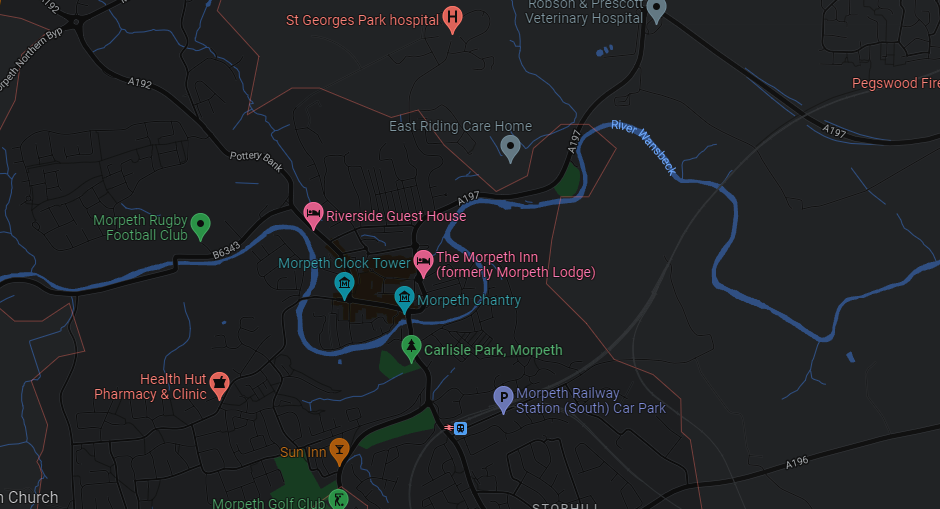
Case study: Morpeth floods
Morpeth lies in a meander bend. It is in northeast England. Basically a big flood happened in September 2008 which was 4 metres above normal river levels at its peak. The ground was already saturated from summer rains, leading to increased surface runoff, and had a short lag time of 8 hours. It is on the lower course of the river, on a flood plain.
Shops, homes and many regions of the town were flooded and destroyed. Now, higher flood walls have been implemented, and a huge upstream reservoir has been created upstream capable of holding 1 million metres cubed of water. Amazing!
Out and about with Rob in Morpeth: https://www.youtube.com/watch?v=XoW6gIDwBSk
Glacial landscapes in the UK
As I took the exams in 2022 with optionality, I did not have time or any notes to write up things to learn about the Glaciation GCSE unit.
Here’s what the specification says.
HOWEVER, notice how I said the glaciation GCSE unit. Luckily, I love Geography and so am currently doing an A level in it, and glaciation just so happens to be one of the physical units.
To view the A level cheat sheet with glaciation information on, as well as to perhaps get a taste for the A level in general, go to this iBaguette cheat sheet.
Note: it contains huge amounts of much more detailed information compared to what you need to know. You can skim read and search through it to find the relevant information.
Paper 2: Challenges in the human environment
As a reminder: not everything is 100% covered in detail, but 95% of the specification is 1:1 matched here.
Section A: Urban issues and challenges
By 2030, it is expected that over 60% of the world’s population will live in cities. Currently, there are 33 megacities (cities with a population > 10 million) and the closest one to us is 🥖 Paris. London is not a megacity, as its population is only predicted to reach 10 million by 2035. After and during the Second World War, many people and children were evacuated from London, so the population shrunk by 2 million from 1940 (at 8.5 million) to 1990. Since then, the population has gradually been increasing, and it’s currently at around 9.2 million. (We’ll have to wait for the census results to be sure!)
In 1975, there were just 4 megacities - Mexico City, New York City, Sao Paulo and Tokyo!
The largest city in the world is Tokyo, Japan, with over 36 million inhabitants (and decreasing). 4 billion people live in urban areas worldwide, and ~12% of these are in megacities. Most of the urban population live in cities with < 5 million residents.
Factors affecting urbanisation
The highest rates of urbanisation are in LICs and NEEs are in Asia and Africa. The majority of their populations remain in rural areas, so more are able to move into urban environments (high rural-urban migration levels), and populations are younger, contributing to a high rate of natural increase (more babies).
People and their families may choose to migrate from the countryside into the cities because of pull factors. This includes better, more consistent and well-paid jobs, and opportunities for better education, as well as more facilities available such as hospitals. Because cities have better healthcare than rural areas (usually) death rates are lower and life expectancy is higher.
Cities are also historically situated on rivers (like London1 and Paris) and coasts (Lagos, New York City, Mumbai) which allow high levels of trade. This allows economic development as more trade is better for business. This economic growth attracts higher-skilled, higher-paid jobs which, in turn, attract more people (could be from rural areas). This cycle is repeated with the new ideas people have attract more economic development.
In richer countries and continents like Europe, Oceania and North America, the rates of urbanisation have significantly slowed down, as most people have already moved into urban areas thanks to industrial revolutions which have already occurred. Due to countries’ wealth, people in these HICs live for longer and tend to have fewer babies, which could lead to natural decrease in the future.
Case study: Lagos, Nigeria
Overview
Lagos is the most populous city in Nigeria, and Africa as a whole. However, it is common knowledge by the vox populi that it is by no means the safest place to live. 2
In 1991, the government of Nigeria moved out of Lagos to Abuja; to this day Abuja is the capital city. However, Lagos has remained critical to the Nigerian economy, with over 80% of the country’s industry based in it, thanks to its international airport, seaport and interconnecting main roads from neighbouring countries like Benin.
Its population is estimated at 19 million, generating a quarter of Nigeria’s wealth. Large companies are headquartered here, and is the main financial centre in West Africa. Nollywood 3 is the Nigerian film industry, again based and thrives here. Alone, this emerging industry is responsible for 2.3% of Nigeria’s GDP.
Growth
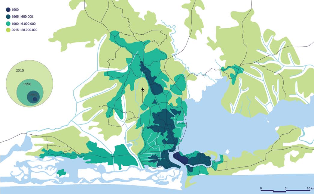
How the area surrounding Lagos has grown over time. Credit Internet Geography
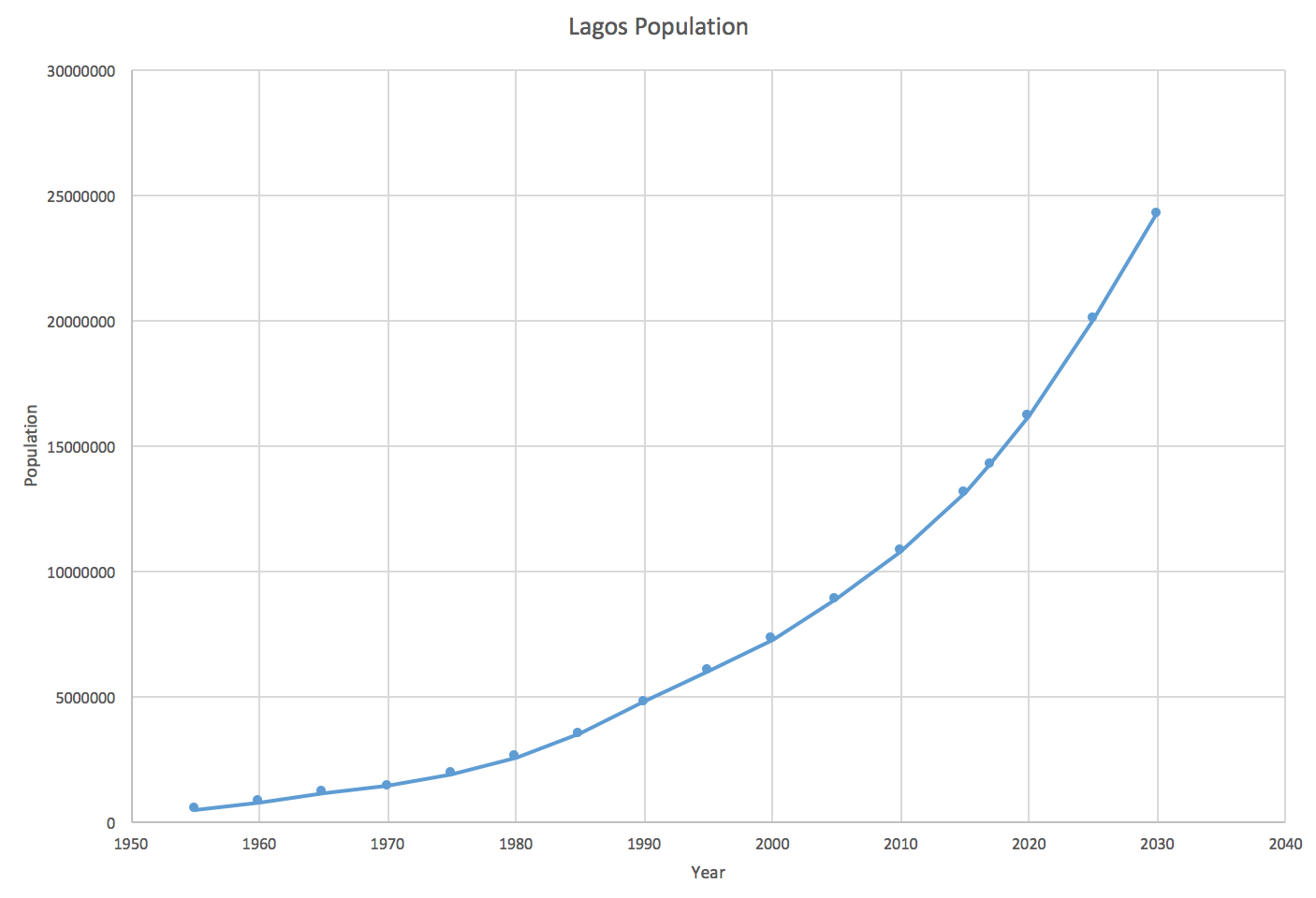
The current, past and future predicted population of Lagos. Credit Internet Geography
The real force for Lagos’ increasing population is rural-urban migration. This is because many people are being forced to leave their countryside jobs and homes due to bad harvests and illness (push factors) and brought to the city by the prospect of better-paid work, education opportunities and better healthcare (pull factors).
Push factors include:
- Poor education and healthcare services (if any)
- Climate change making harvests more unpredictable and more droughts
- Low farming wages
- Shortage of land due to population increase
- Land continually being degraded due to continual farming and oil pollution
Opportunities and challenges
Education is more available - many schools and universities are being built. Children are given 9 years of basic education (increasing literacy rates from 65 to 95%). Furthermore, healthcare is better inside Lagos than in rural areas - hospitals are more frequent inside the city, so people can get help if they are ill. Even though most treatments aren’t free, it’s better than not having these facilities.
Energy is an issue in Lagos due to the rapidly increasing population. As a result, when the grid fails, many homes and businesses are forced to rely on diesel generators. Obviously these cannot be used by poorer residents, who instead rely on tapping into the network which is unsafe.
Water is an issue too as only wealthy residents can afford a piped water supply. This is a total of just 10% of the population. There is huge strain on the infrastructure to provide for all homes and, despite improvements, many people are often forced to buy from street vendors which may be contaminated - this is part of the informal economy. On buying from the informal economy, taxes are not paid, which cannot be reinvested in the infrastructure. People have been digging boreholes into the groundwater, but the water from the lagoon is salty and heavily polluted. Faecal bacteria have entered the water supply and diseases like cholera and dysentery have been increasing.
Unemployment is a serious issue as there is no unemployment benefit in Nigeria, so people are forced to find any available work, like in the informal economy.
The informal economy has many negatives, being unregulated, dangerous and poorly paid. 40% of workers in Lagos are paid under £1 per day! This has severe consequences: over 60% of the population live in slums like Makoko, building their homes on any bit of available land with any material which they might have. Despite this, levels of crime are falling but ‘Area Boys’ may patrol streets in gangs and violence may ensue.
Lagos has extremely dirty air with dangerous levels of N2O and small dust particles (particulate matter). These are both hazardous to human health and can cause diseases, like asthma. This is being fuelled by increasing car usage in the city (20% of homes have one). On top of this, congestion and traffic in the city is terrible, with the average commuter spending 3 hours a day in traffic. To combat this, the government are building an integrated transport system, linking railways and roads. A waterway network with ferries and boating across the lagoon instead of taking cars is also being created. There is also a separate lane for buses from the northern suburbs travelling into Lagos Island. This will improve travel times for over 25% of people who commute daily, a total of 200,000 people.
Waste is an issue too. With waste collecting infrastructure from the 1970s, where the population was 10x smaller, Lagos now produces over 10,000 tons of solid waste per day! The Olusosun landfill site receives the bulk of this, with many hundreds of people working there and even building homes from the trash to sort rubbish and find valuables. However, fires are likely, with natural gases building up below the dump. E-waste is also imported from HICs which contribute to toxic gases being released. In total, air pollution is 5x higher than the internationally agreed limit.
Economic opportunities
More jobs are available in Lagos than in anywhere else in Nigeria, responsible for 25% of the country’s GDP. Lagos itself is a large manufacturing hub - being a seaport also helps this, and is culturally significant with Nollywood. Furthermore, technology is improving in this area significantly, with large companies investing in the area resulting in the improvements of infrastructure like fibre optic broadband. Despite the inequalities, Lagos has a thriving, highly-educated and skilled workforce, thanks to its top universities.
A new city on the south side of Lagos, in the Gulf of Guinea, is being made. Called Eko Atlantic, it is a land reclamation project, which will be home to the new financial hub of Western Africa. Dubbed ‘the Dubai of Africa’ from this google maps reviewer, many international investors are looking forward to the project’s completion. It will be home to over 250,000 people and employing a further 150,000 in skyscrapers and high-rise office buildings. This will be possible thanks to its independent electricity grid and water desalination plants.
6.5km of sea wall has been built to protect the project from the sea and erosional processes. Website
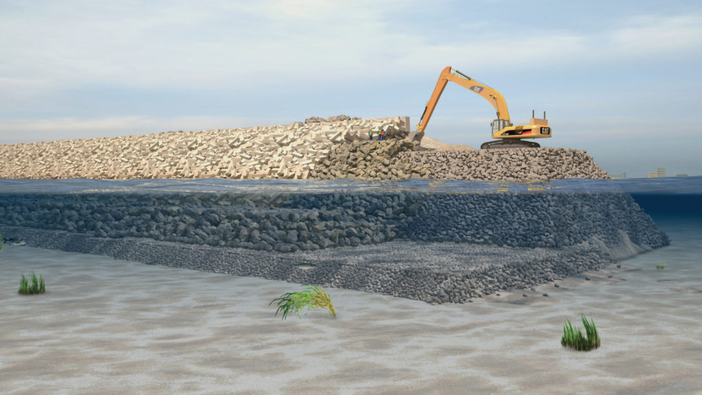
Building the protective wall.
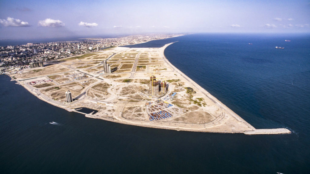
Eko Atlantic’s 6,500,000m2 of land, reclaimed.
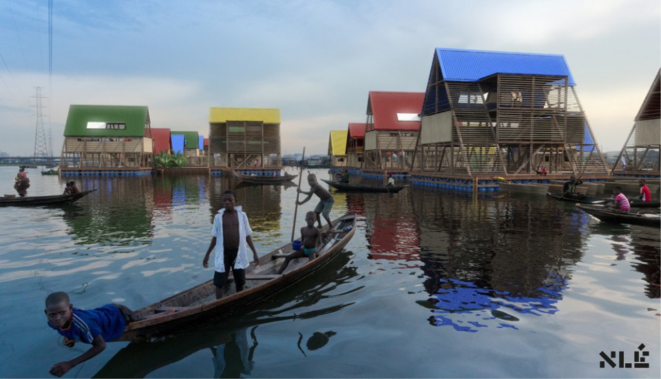
Makoko - Urban planning for the urban poor (example)
The Nigerian government’s goals are to attract private investors which will help them create a new city, creating highly-paid jobs and new, luxury homes.
Many of Makoko’s tin and wooden houses are built on stilts. However, during the rain season, many buildings on land and low-lying areas are submerged, including the main school.
Built in 2014, the Makoko Floating School is environmentally friendly, having photovoltaic solar panels, natural ventilation, green areas and a rainwater collection system. As it floats on 256 recycled plastic barrels, the platforms rise and fall with the sea level, futureproofing these structures against sea level rise, augmented by climate change. Finally, there are several compost toilets, which is better for the environment as all sewage is usually thrown into the lagoon. (Makoko people eat the fish, so that’s not good…)4
The school can hold up to 100 students with 4 classrooms and 2 workshops on the upper storey, and a communal, open space on the lower level. In total, there is 100m2 of space. Its triangular shape and low centre of gravity helps keep the structure stable.
Unfortunately, the school collapsed during a storm in 2017. The idea has continued to remain in developers’ minds and ‘the Lagos Water Communities Project’ is an idea for these poorer communities. Compared to the Eko Atlantic’s several million dollar sea defence wall, this low-cost scheme may significantly ameliorate the lives of the vox populi in Makoko and Lagosian slums.
The floating school acted as a proof-of-concept, not a final, fixed structure. It would have been able to be reconfigured as a house, community space, shop and more if the final version was able to be structurally secure.6
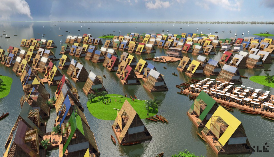
An artist’s impression on what a floating community would look like. Credit: NLÉ
Case study: London
In the UK, the population is vastly distributed. The key to this is the northwest/southeast divide. In the south east, cities are increasing in populations, especially as the south east has the fastest growing economy in the UK. However, in the northeast, Sunderland has actually lost over 2% of its population from 2004 due to the decline of industry which was historically popular, leading to less job opportunities, forcing people to move away to find work.
In London, the population density can be up to 5000/km2. In contrast, northern Scotland has a population density of less than 10/km2!
London is very important nationally and internationally. It is regarded as the ‘finance hub’ of the UK, with Barclays, HSBC and Lloyd’s Bank being headquartered here. It was built by the Romans as it is on the River Thames - allowing trade from other nations. In the past, due to the river being tidal, ships are able to travel up the Thames to London’s docks. In turn, the business opportunities provided by its proximity to the seas attracted more people to the area.
Gentrification is the term used to describe the prices of rising house prices in an area as a result of higher wages and more modern amenities.
As a result from high levels of migration from the 19th Century, many from major British colonies like India and Nigeria, London is only made up of 45% White British nationals, and 37% not being born in the UK. Furthermore, its population is also larger and younger than any other UK city. This is because young(er) people from 20-40 like university students move to London for better job opportunities, spurred on by higher pay due to the higher cost of living. These younger people are also more likely to have children, contributing to higher natural increase, while migration itself is fairly low now. After Brexit, the restriction of free movement within the EU will most likely lower this migration trend even further in the UK. In 3 boroughs, white people are in the minority!
Because of high migration and a diverse community, London is seen as a ‘melting pot’ for cultures. Entrepreneurs are more likely to create diverse shops to account for this, such as halal butchers, and services are also more likely to accommodate these different cultures, for example mosques.
London also has a wide range of recreation and entertainment available. There are cultural attractions like the British Museum and the Natural History Museum, tourist attractions like the Houses of Parliament and Buckingham Palace, venues like the O2 and Wembley Stadium and loads of bars and restaurants.
London also has a highly developed integrated transport system. This is when all modes of transport link to each other - responsible for the high use rate of public transport, at 25%. There is the London Underground, typical red double-decker buses, and the Docklands Railway. Recently, the Crossrail project has contributed to the reduction of journey times throughout London in half, for example Liverpool Street to Heathrow now takes 35 minutes from over an hour.
The Oyster Card provides low-cost efficient travel basically anywhere in the city. Boris bikes are also used to provide an integrated cycle network, providing 2.5% of London’s journeys daily, or 750,000. Furthermore, private transport is also used in London significantly, with it being a travel hub where many motorways converge on its orbital motorway, the M25. There are also 5 international airports, most notably Gatwick, Heathrow and Stansted. They handled 177 million passengers in 2018, or 60% of the UK’s air traffic.5 In 2014, 75 million passengers used the Tube, with a total of 1,300 million journeys in that year.
Urban greening is how green spaces are increased and maintained in cities. For example, London is one of the most green cities in the world. Around half (47%) of the city is green space, including parks, gardens and woods. Hyde Park is a large public place in central London. Councils also run smaller parks in other boroughs, as the Government in the 1800s believed that fresh air was essential for the population.
These green spaces are beneficial to the city:
- oxygen is produced, cleaning the ear from CO2;
- trees intercept water flow, reducing flood risk;
- parks and woodlands act as a habitat for wildlife;
- allotments can be used to grow food.
To further improve these green spaces, a ‘green grid’ has been created to link open spaces throughout London, reducing animal deaths. London was also given the title of a ‘National Park City’ - the first in the world - in 2019, with the goal of improving all aspects of outdoor life and enjoyment.
Shoreditch, London
Shoreditch is a great example of an area which has undergone gentrification. Older, industrial buildings like factories have been demolished and replaced by higher value flats, offices and restaurants. In the centre of the area, the roundabout has been nicknamed Silicon Roundabout due to the amount of technological companies who have interested in the area, like Google and Microsoft. As a result of this amelioration, jobs have been created in these new industries like art and full-stack developers (these are the ones who make front end and back end design, so like web design and database maintenance).
As older residents are moving out due to increased prices, younger and more professional workers take their place. Entrepreneurs have responded to this by creating new, modern themed cafés for day traffic, and clubs and nightclubs for the night audience.
Dockyard development & changing employment
The docks were built through the 20th century to import and export the huge amounts of raw materials, being England’s busiest city. Industries were built in close proximity to these docks to process the raw materials. However, by the 1970s, catalysed by the Second World War, many industries were in decline and also the docks. 10 years later most docks were empty, and do were the factories.
The London Docklands Development Corporation, ran by the Government, was set up in 1981. As a result of the regeneration which was planned, many private companies invested in the area. By 1991, the first stage of improvements were completed; now it is known as Canary Wharf. Over 100,000 people now work there, with the UK’s major old banks headquartered here.
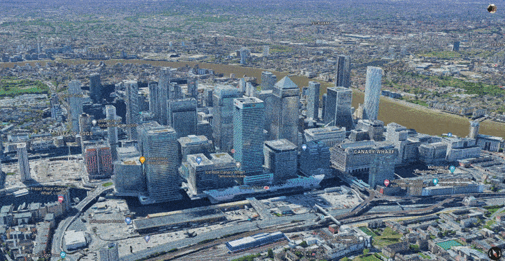
Canary Wharf from Google Maps
Urban challenges & urban sprawl
London’s population is growing at 5x the rate of houses being built, with a population increase of 100,000 per year. As a result, there is a housing shortage throughout London and south-east England, augmenting house prices. In 2020, there were 170,000 homeless in London, not helped by COVID making people redundant.
To combat this, either greenfield or brownfield sites need to be built on.
Greenfield sites:
- contribute to urban sprawl
- are usually from farmland, which produces food, or recreational land
- can destroy natural habitats
- are unlikely to turn back to countryside
- are fairly cheap due to the rurality
Brownfield sites:
- reduce the need for urban sprawl
- are more readily available due to the decline of industry
- may require buildings to be demolished prior to construction, but reduce dereliction
- can improve the pre-existing urban environment
- are more expensive due to usually being in rural areas
- may require the land to be decontaminated from chemicals and waste
Urban sprawl is the unplanned, rapid growth of urban areas. To combat this, many cities including London established a ‘green belt’ - an area around the city which has very strict planning permission. This has preserved areas of farmland and woodlands around London.
Being able to plan and control housing developments is why almost 50% of London’s land is ‘green’ and why there is almost a 1:1 resident: tree ratio!
However, this has had unintended consequences. The average house price in London is over double what it is in the rest of the UK, and rising rapidly. Many campaigners are pressuring the Government for less economically valuable areas to be used as greenfield sites to relieve the pressure on London’s housing crisis.
Another result of the green belt is the growth of commuter settlements around London. Reading is an example of this, being just a 30 minute train journey into the City of London (right in the middle) and outside the green belt, this has attracted many thousands of people and families to the town. This results in the spread of housing estates and business areas spreading into the countryside surrounding. Some may argue that this completely goes against the purpose of the green belt in the first place! (potential 9 marker)
The Lower Lea Valley
Alternately known as the place where the Olympic Park was built for 2012. (Stratford)
This area, prior to its restoration, was heavily contaminated with chemicals from industry. The industrial buildings were derelict and overgrown. On the other hand there were a couple of functioning industrial areas employing around 5,000 workers among 250 business.
The London 2012 Olympic Legacy was a plan to ensure the Olympic Games had significant long term benefits for the area.
ECONOMIC benefits
Stratford received a Tube station to connect it to the rest of London. It is now the second most connected area of the city! The Olympics directly resulted in £9 billion for east London, and Lloyds Bank estimated that another £10 billion will be generated from the Olympics. The media centre was sold to a data company, Infinity, who store data for large corporations. The total cost for the Olympics was £8.77 billion - from taxpayers.
However, the stadium cost £700 million, which was 3x the estimate.
SOCIAL benefits
The Athletes’ Village created for the Olympians has been repurposed (not demolished) as a housing estate called the East Village. Around 1,300 homes were made, most of which categorised as ‘affordable housing’. In total 8,000 people will be able to be housed. A school was also opened in the grounds of the park, relieving the shortage of space before it was built. The new pools built for the Olympics are now being used for this school, as well as the community, and also athletes training.
However, properties for poorer residents were demolished, including 450 flats. Few jobs were created for local residents during construction, and many thought it was a missed opportunity to train unskilled workers. As a result, many people round still live in poverty and in Tower Hamlets unemployment actually increased.
ENVIRONMENTAL
Many grounds in the Olympic Park have been kept as parkland for the public. Ponds, woodlands and artificial otter holes have been created in the area. The stadiums were made from 25% recycled material, and green spaces were placed along the River Lea to improve its water quality. It was built on over 500 acres of brownfield site, from derelict and contaminated land to newer, modern, loved areas. Over 300,000 plants were specially selected for biodiversity and sustainability in the urban environment.
However, many materials for the park were sourced from overseas, whilst the games produced over 3 million tons of CO2.
You don’t need to remember all the precise stats and figures - just a few - I have rounded some figures and simplified them a bit to make them easier to remember.
Urban living in East Village (again around the Olympic area).
Local bus and transport services connect to the London Underground, as well as Europe. Residents in the East Village pay extra for car parking places, encouraging cycling and walking.
Water is 50% less used than other urban areas, achieved by water recycling. Rainwater is recycled and filtered through ponds before being used for toilet flushing and irrigation. Green roofs on buildings also slow down rates of drainage, mitigating flood risk, and allowing more water to be used for irrigation or other conservation systems. (Drinking water is different!)
Energy is also conserved as it makes use of the combined heat and power system. It basically generates electricity, producing heat from burning biomass. This heat can be used to heat water. As it is piped through the village, it gently cools, and this cool water is piped back into the CHP station.
Green spaces have also been created. There are green roofs on apartments blocks, a wetland pond area, 10 hectares of open green space, a large central park and an orchard with fruit trees.7
Section C: The challenge of resource management
In this section, students are required to study Resource management and one from Food or Water or Energy.

You need to learn about all of them as an overview, but only one in particular, and food in more detail in this case.
Simply put, the more availability to food, water and energy a country has, the better the citizens’ well-beings are.
Quick summary of everything overall:
Food:
-
There is a growing demand for high-value food exports from low income countries and an all-year demand for seasonal food and organic produce. As a result of this, many countries, especially in Africa, have less land available for locals to cultivate on and support their families in. It reduces the water supply in areas where this is already unreliable - e.g. Kenya is on the equator, and many beans come from there. This increases the likelihood of droughts and desertification (paper 1 knowledge).
-
Carbon footprints are higher when outsourcing food supply to other countries, due to the increasing number of ‘food miles’ travelled. To combat this, there are moves towards local sourcing of food, with ‘locally sourced’ and ‘Red Tractor’ labels. Farm shops throughout the countryside also are well known to grow food on-site, albeit at a higher price. Organic produce is also gaining popularity which uses natural fertilisers and mechanical weeding, which does not pollute the water supply, and chemicals are not being ingested by humans who eat the food.
-
There is a trend towards agribusiness. This is when a farm is run large-scale with money-intensive commercial activities. This has resulted in fields increasing in size, with smaller farms being combined and the increased mechanisation of farm equipment. It also relies on pesticides and fertilisers more which has a negative impact on l’environnement and reduces employment. The positives include cheaper prices as food is more available and overhead costs have decreased, and skilled jobs with technology are provided to skilled workers.
Water:
- There is a changing demand for water in the UK. In northern areas, there is a high supply of water but low demand for it - the population density is low, with there only being a few cities. The reason why there is a lot of water here is because there is a lot orographic rainfall (mountains). In the south and southeast, there are low levels of waterfall and high levels of water stress, so transfer schemes are in place like dams and reservoirs on rivers to allow water to be moved from areas of water surplus to areas of water deficit - usually pumped.
The average person uses 150 litres of water in the UK per day
- This can only be done if the water quality is high and pollution is managed - toxic waste can poison wildlife, and eutrophication can kill plants due to plant life building up so much in the river or lake, reducing oxygen levels, suffocating the animals. Raw sewage and other waste must be treated at a treatment plant. It can also be managed by legislation, education campaigns, pollution traps and green roofs and walls.
Energy:
- the changing energy mix – reliance on fossil fuels, growing significance of renewables
- reduced domestic supplies of coal, gas and oil
- economic and environmental issues associated with exploitation of energy sources.
Food
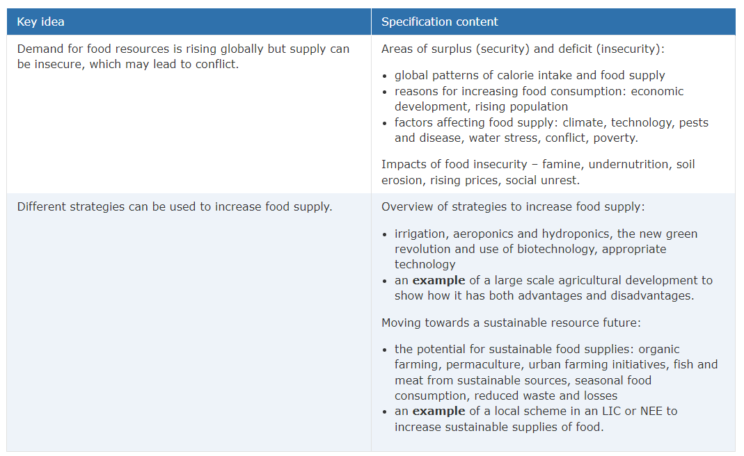
Food, yummy. I really couldn’t live without it.
Food security is defined as ‘when all people at all times have access to sufficient, safe, nutritious food to maintain an active and healthy life’.
Worldwide, enough food is produced for everyone, but it is distributed differently. In mostly Africa and Southern Asia, there are high risks of food insecurity. In HICs, over 25% of the diet is made from meat, fish, eggs, milk and cheese and another quarter from cereals. In LICs, half the diet is made from cereals. Although high in calories, they are low in nutrients, resulting in malnourishment.
Several factors affect food supply and consumption:
Food demand factors
- Population growth: more mouths to feed requires more food to be produced. In LICs, where there is a deficit, everyone will get less nutrients.
- Economic development - as people in NEEs become more wealthy, they eat more meat and feed animals, resulting in resources being allocated for their own country rather than others.
- Climate - droughts can cause huge losses of crops and livestock, and also increasing the risks of desertification, reducing fertile farmland areas.
- Floods can also cause losses of crops and livestock, especially on coastal areas after tropical storms.
- Climate change is exaggerating these with weather patterns becoming more unpredictable while also increasing drought length and frequency of these and tropical storms.
- Not good.
- Technology - LICs cannot afford to invest in infrastructure which could increase yield of crops, like stable roads, machinery for cultivation and things like GM laboratories.
- Pests and disease - pests like rats can eat the produce in warehouses like silos after a harvest, diseases like malaria and cholera can reduce the workforce.
- Water stress - is when annual freshwater per person is below 1,700m3/year. HICs can manage water stress through transfer schemes and irrigation to produce food, while LICs can’t. Floods can also contaminate water supplies.
- Conflict & social unrest - wars can disrupt farming and food production. It also may displace many people who do not have the money or facilities to grow or buy food. The need for water can lead to international disputes over ownership of water sources, like in the River Nile.
Food supply factors
- Irrigation - used to supply extra water to farming areas, especially if water supply naturally is low. It increases crop yields and income, reducing poverty. If used economically, such as drip irrigation (delivered directly to roots reducing evaporation) it can improve the quality of live for everyone involved. However it can cause salinization (build up of salt) if the source is the sea, for example. It also costs a lot to maintain.
- Aeroponics - when air is used to grow plants. Nutritional water is sprayed to the plants regularly, in a greenhouse to avoid evaporation. It is easily maintainable, requires less nutrients as they do not go into the soil, and needs little space. It can be expensive and knowing the exact nutrients can require specialist knowledge.
- Hydroponics - when plants’ roots are constantly in water. They grow faster, like in aeroponics, as more nutrients are available. Diseases and funguses in the soil do not exist here. Similar disadvantages to aeroponics.
- The New Green Revolution - when new strains of seeds were developed with a higher yield. Yields increases by 40% in Asia and larger quantities of cheaper foods were produced. The New Green Revolution will conserve biodiversity while improving all aspects of farming and having the least impact on the environment.
- Biotechnology - GM crops and animals can be made to have more vitamins and proteins, more resistant to salts, droughts, insects and diseases, better flavours and better lifespan of foods after harvesting.
Aquaponics is when plants and animals are grown together - the fish produce nitrifying bacteria which give nitrates to the plant, increasing growth and yield.
Case study: Almeria, Spain
Almeria is a large scale agricultural development. Greenhouses cover 31,000 hectares of land. It is responsible for most of the UK’s out of season crops like tomatoes and cucumbers, generating 1.5 billion dollars for the Spanish economy. It supplies half of Europe’s fruit and vegetables. It has got so big because of:
- Changing demand for more fruit and veg
- High demand for out of season produce - HICs want this all year round
- Fast and easy shipping internationally
- Hot average temperature allowing for little extra energy to be required to grow the crops
- Cheap labour from (typically African) immigrants who want to earn money
Advantages include
- Low water use due to drip irrigation and hydroponics
- Fresh water via a desalination plant is available as it’s next to the Mediterranean Sea
- Jobs created in packing and manufacturing plants
- Very cheap produce produced
- Regulations increase food safety by reducing chemical uses.
Disadvantages include
- Immigrants are paid low wages and live and work in poor conditions
- The use of pesticides increase health risks for workers and contaminating water supplies
- Natural ecosystems have been COMPLETELY destroyed - there’s so much plastic covering everything!
- Natural water sources like aquifers are drying up
- Plastic pollution is being dumped in the sea affecting marine life
Temperatures in the area have dropped by 0.3oC in the area as the greenhouses are white and reflect sunlight!
[tbd] Example of a local scheme an LIC/NEE
This section is to be determined as I do not have any notes for it. I had to ask my teacher literally a couple of minutes before the exam about it, as it is right at the end of the specificaiton, for information which I just managed to remember.
Despite everyone else betting against me that it wouldn’t come up in the exam, it was the last question and a 6 marker in the 2022 exam series. Good luck!
Footnotes
1 I’m saying London here as, although it’s not (currently) a megacity, it’s always been a significant trading hub and economic powerhouse for the UK and globally.
2 The most waffle I’ve written today, almost as bad as my Chemistry 6 markers
4 Amended from Sam’s document. Lagos_Overview_-_Sam_Fisher_-_10th_Feb_-_10Q.docx
5 I spent ages looking and found this article on Wikipedia.
6 Credits to Jacob for this idea. discord link
7 How to get a free phone - just go here and eat as many apples as you can!
Fin
You’ve made it to the end!
Good luck with your exams!
Feel free to share this Cheat Sheet with friends, family and teachers.
Made with 💕 by Draggie