< Back to all GCSE Cheat Sheets
AQA Geography GCSE - Complete Paper 2 (Human) Cheat Sheet! (8035)
Latest update: 30/09/2023 13:51.
Latest content addition: 20/05/2023 22:25
READ THIS:
Please use your class notes, if you have any, as well as this, to aid your revision. Although this document matches the specification 1:1 and covers it entirely, it is condensed into one place, so might not cover everything in 100% detail. I have tried to write more content for the topics/ideas which people may find confusing. If there are any errors then please let me know immediately (Discord: @draggie). I have tried my best to make it as easy as possible to understand and get a top grade ;)
Looking to ace your exams with easy-to-access, free 1:1 advice from exam survivors? Discuss with other students, developers, educators and professionals in the Baguette Brigaders Discord server who can answer all your questions and give you tips and tricks! Plus, you can opt to receive automatic notifications whenever new content is added here!
Section A: Urban issues and challenges
By 2030, it is expected that over 60% of the world’s population will live in cities. Currently, there are 33 megacities (cities with a population > 10 million) and the closest one to us is 🥖 Paris. London is not a megacity, as its population is only predicted to reach 10 million by 2035. After and during the Second World War, many people and children were evacuated from London, so the population shrunk by 2 million from 1940 (at 8.5 million) to 1990. Since then, the population has gradually been increasing, and it’s currently at around 9.2 million. (We’ll have to wait for the census results to be sure!)
In 1975, there were just 4 megacities - Mexico City, New York City, Sao Paulo and Tokyo!
The largest city in the world is Tokyo, Japan, with over 36 million inhabitants (and decreasing). 4 billion people live in urban areas worldwide, and ~12% of these are in megacities. Most of the urban population live in cities with < 5 million residents.
Factors affecting urbanisation
The highest rates of urbanisation are in LICs and NEEs are in Asia and Africa. The majority of their populations remain in rural areas, so more are able to move into urban environments (high rural-urban migration levels), and populations are younger, contributing to a high rate of natural increase (more babies).
People and their families may choose to migrate from the countryside into the cities because of pull factors. This includes better, more consistent and well-paid jobs, and opportunities for better education, as well as more facilities available such as hospitals. Because cities have better healthcare than rural areas (usually) death rates are lower and life expectancy is higher.
Cities are also historically situated on rivers (like London1 and Paris) and coasts (Lagos, New York City, Mumbai) which allow high levels of trade. This allows economic development as more trade is better for business. This economic growth attracts higher-skilled, higher-paid jobs which, in turn, attract more people (could be from rural areas). This cycle is repeated with the new ideas people have attract more economic development.
In richer countries and continents like Europe, Oceania and North America, the rates of urbanisation have significantly slowed down, as most people have already moved into urban areas thanks to industrial revolutions which have already occurred. Due to countries’ wealth, people in these HICs live for longer and tend to have fewer babies, which could lead to natural decrease in the future.
Case study: Lagos, Nigeria
Overview
Lagos is the most populous city in Nigeria, and Africa as a whole. However, it is common knowledge by the vox populi that it is by no means the safest place to live. 2
In 1991, the government of Nigeria moved out of Lagos to Abuja; to this day Abuja is the capital city. However, Lagos has remained critical to the Nigerian economy, with over 80% of the country’s industry based in it, thanks to its international airport, seaport and interconnecting main roads from neighbouring countries like Benin.
Its population is estimated at 19 million, generating a quarter of Nigeria’s wealth. Large companies are headquartered here, and is the main financial centre in West Africa. Nollywood 3 is the Nigerian film industry, again based and thrives here. Alone, this emerging industry is responsible for 2.3% of Nigeria’s GDP.
Growth
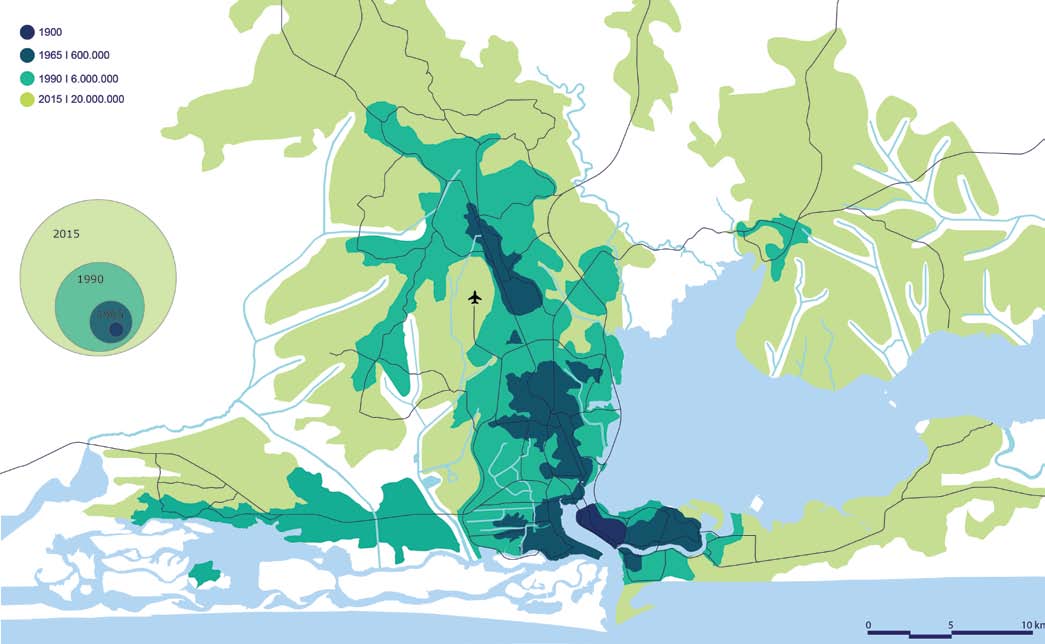
How the area surrounding Lagos has grown over time. Credit Internet Geography
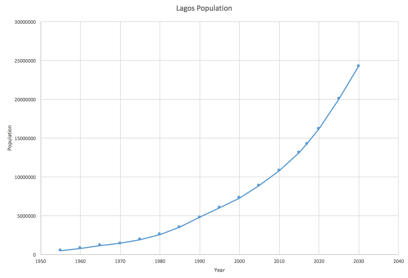
The current, past and future predicted population of Lagos. Credit Internet Geography
The real force for Lagos’ increasing population is rural-urban migration. This is because many people are being forced to leave their countryside jobs and homes due to bad harvests and illness (push factors) and brought to the city by the prospect of better-paid work, education opportunities and better healthcare (pull factors).
Push factors include:
- Poor education and healthcare services (if any)
- Climate change making harvests more unpredictable and more droughts
- Low farming wages
- Shortage of land due to population increase
- Land continually being degraded due to continual farming and oil pollution
Opportunities and challenges
Education is more available - many schools and universities are being built. Children are given 9 years of basic education (increasing literacy rates from 65 to 95%). Furthermore, healthcare is better inside Lagos than in rural areas - hospitals are more frequent inside the city, so people can get help if they are ill. Even though most treatments aren’t free, it’s better than not having these facilities.
Energy is an issue in Lagos due to the rapidly increasing population. As a result, when the grid fails, many homes and businesses are forced to rely on diesel generators. Obviously these cannot be used by poorer residents, who instead rely on tapping into the network which is unsafe.
Water is an issue too as only wealthy residents can afford a piped water supply. This is a total of just 10% of the population. There is huge strain on the infrastructure to provide for all homes and, despite improvements, many people are often forced to buy from street vendors which may be contaminated - this is part of the informal economy. On buying from the informal economy, taxes are not paid, which cannot be reinvested in the infrastructure. People have been digging boreholes into the groundwater, but the water from the lagoon is salty and heavily polluted. Faecal bacteria have entered the water supply and diseases like cholera and dysentery have been increasing.
Unemployment is a serious issue as there is no unemployment benefit in Nigeria, so people are forced to find any available work, like in the informal economy.
The informal economy has many negatives, being unregulated, dangerous and poorly paid. 40% of workers in Lagos are paid under £1 per day! This has severe consequences: over 60% of the population live in slums like Makoko, building their homes on any bit of available land with any material which they might have. Despite this, levels of crime are falling but ‘Area Boys’ may patrol streets in gangs and violence may ensue.
Lagos has extremely dirty air with dangerous levels of N2O and small dust particles (particulate matter). These are both hazardous to human health and can cause diseases, like asthma. This is being fuelled by increasing car usage in the city (20% of homes have one). On top of this, congestion and traffic in the city is terrible, with the average commuter spending 3 hours a day in traffic. To combat this, the government are building an integrated transport system, linking railways and roads. A waterway network with ferries and boating across the lagoon instead of taking cars is also being created. There is also a separate lane for buses from the northern suburbs travelling into Lagos Island. This will improve travel times for over 25% of people who commute daily, a total of 200,000 people.
Waste is an issue too. With waste collecting infrastructure from the 1970s, where the population was 10x smaller, Lagos now produces over 10,000 tons of solid waste per day! The Olusosun landfill site receives the bulk of this, with many hundreds of people working there and even building homes from the trash to sort rubbish and find valuables. However, fires are likely, with natural gases building up below the dump. E-waste is also imported from HICs which contribute to toxic gases being released. In total, air pollution is 5x higher than the internationally agreed limit.
Economic opportunities
More jobs are available in Lagos than in anywhere else in Nigeria, responsible for 25% of the country’s GDP. Lagos itself is a large manufacturing hub - being a seaport also helps this, and is culturally significant with Nollywood. Furthermore, technology is improving in this area significantly, with large companies investing in the area resulting in the improvements of infrastructure like fibre optic broadband. Despite the inequalities, Lagos has a thriving, highly-educated and skilled workforce, thanks to its top universities.
A new city on the south side of Lagos, in the Gulf of Guinea, is being made. Called Eko Atlantic, it is a land reclamation project, which will be home to the new financial hub of Western Africa. Dubbed ‘the Dubai of Africa’ from this google maps reviewer, many international investors are looking forward to the project’s completion. It will be home to over 250,000 people and employing a further 150,000 in skyscrapers and high-rise office buildings. This will be possible thanks to its independent electricity grid and water desalination plants.
6.5km of sea wall has been built to protect the project from the sea and erosional processes. Website
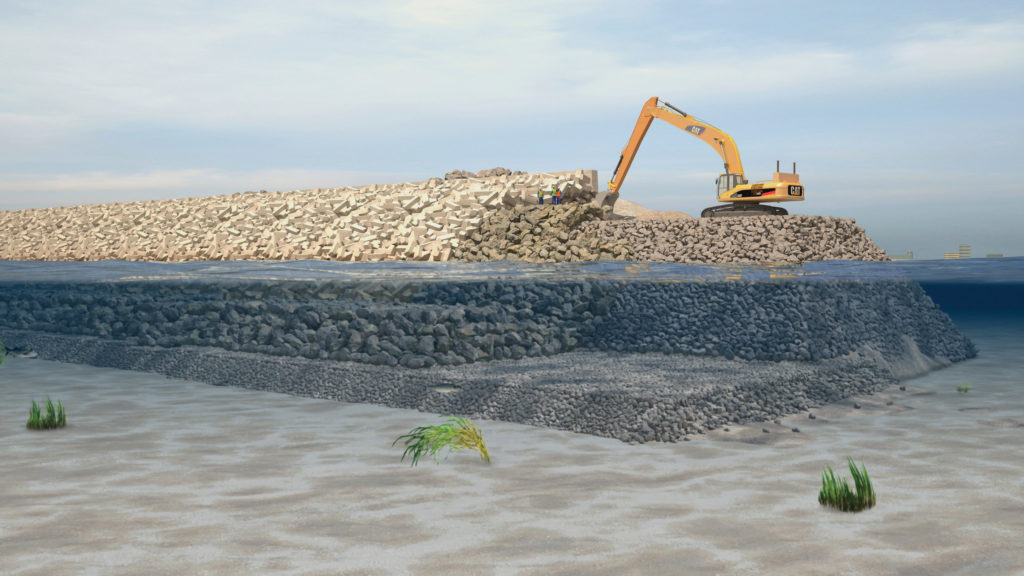
Building the protective wall.
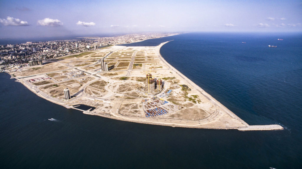
Eko Atlantic’s 6,500,000m2 of land, reclaimed.
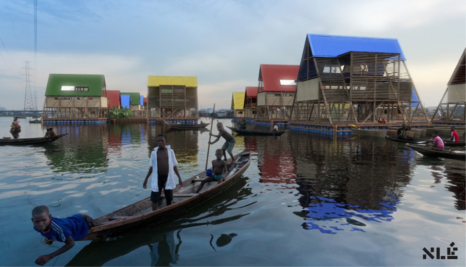
Makoko - Urban planning for the urban poor (example)
The Nigerian government’s goals are to attract private investors which will help them create a new city, creating highly-paid jobs and new, luxury homes.
Many of Makoko’s tin and wooden houses are built on stilts. However, during the rain season, many buildings on land and low-lying areas are submerged, including the main school.
Built in 2014, the Makoko Floating School is environmentally friendly, having photovoltaic solar panels, natural ventilation, green areas and a rainwater collection system. As it floats on 256 recycled plastic barrels, the platforms rise and fall with the sea level, futureproofing these structures against sea level rise, augmented by climate change. Finally, there are several compost toilets, which is better for the environment as all sewage is usually thrown into the lagoon. (Makoko people eat the fish, so that’s not good…)4
The school can hold up to 100 students with 4 classrooms and 2 workshops on the upper storey, and a communal, open space on the lower level. In total, there is 100m2 of space. Its triangular shape and low centre of gravity helps keep the structure stable.
Unfortunately, the school collapsed during a storm in 2017. The idea has continued to remain in developers’ minds and ‘the Lagos Water Communities Project’ is an idea for these poorer communities. Compared to the Eko Atlantic’s several million dollar sea defence wall, this low-cost scheme may significantly ameliorate the lives of the vox populi in Makoko and Lagosian slums.
The floating school acted as a proof-of-concept, not a final, fixed structure. It would have been able to be reconfigured as a house, community space, shop and more if the final version was able to be structurally secure.6
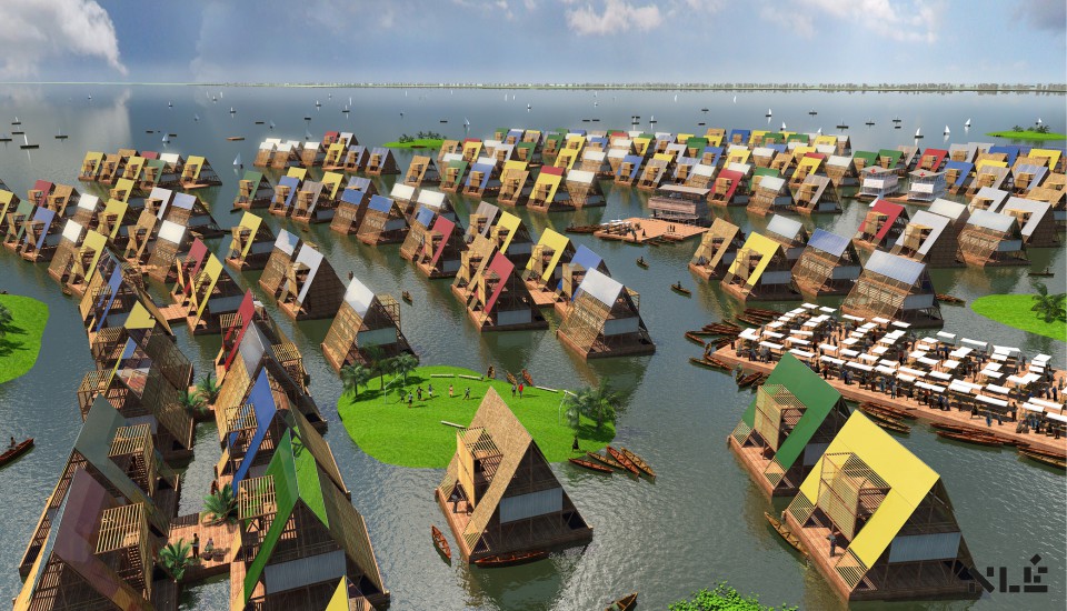
An artist’s impression on what a floating community would look like. Credit: NLÉ
Case study: London
In the UK, the population is vastly distributed. The key to this is the northwest/southeast divide. In the south east, cities are increasing in populations, especially as the south east has the fastest growing economy in the UK. However, in the northeast, Sunderland has actually lost over 2% of its population from 2004 due to the decline of industry which was historically popular, leading to less job opportunities, forcing people to move away to find work.
In London, the population density can be up to 5000/km2. In contrast, northern Scotland has a population density of less than 10/km2!
London is very important nationally and internationally. It is regarded as the ‘finance hub’ of the UK, with Barclays, HSBC and Lloyd’s Bank being headquartered here. It was built by the Romans as it is on the River Thames - allowing trade from other nations. In the past, due to the river being tidal, ships are able to travel up the Thames to London’s docks. In turn, the business opportunities provided by its proximity to the seas attracted more people to the area.
Gentrification is the term used to describe the prices of rising house prices in an area as a result of higher wages and more modern amenities.
As a result from high levels of migration from the 19th Century, many from major British colonies like India and Nigeria, London is only made up of 45% White British nationals, and 37% not being born in the UK. Furthermore, its population is also larger and younger than any other UK city. This is because young(er) people from 20-40 like university students move to London for better job opportunities, spurred on by higher pay due to the higher cost of living. These younger people are also more likely to have children, contributing to higher natural increase, while migration itself is fairly low now. After Brexit, the restriction of free movement within the EU will most likely lower this migration trend even further in the UK. In 3 boroughs, white people are in the minority!
Because of high migration and a diverse community, London is seen as a ‘melting pot’ for cultures. Entrepreneurs are more likely to create diverse shops to account for this, such as halal butchers, and services are also more likely to accommodate these different cultures, for example mosques.
London also has a wide range of recreation and entertainment available. There are cultural attractions like the British Museum and the Natural History Museum, tourist attractions like the Houses of Parliament and Buckingham Palace, venues like the O2 and Wembley Stadium and loads of bars and restaurants.
London also has a highly developed integrated transport system. This is when all modes of transport link to each other - responsible for the high use rate of public transport, at 25%. There is the London Underground, typical red double-decker buses, and the Docklands Railway. Recently, the Crossrail project has contributed to the reduction of journey times throughout London in half, for example Liverpool Street to Heathrow now takes 35 minutes from over an hour.
The Oyster Card provides low-cost efficient travel basically anywhere in the city. Boris bikes are also used to provide an integrated cycle network, providing 2.5% of London’s journeys daily, or 750,000. Furthermore, private transport is also used in London significantly, with it being a travel hub where many motorways converge on its orbital motorway, the M25. There are also 5 international airports, most notably Gatwick, Heathrow and Stansted. They handled 177 million passengers in 2018, or 60% of the UK’s air traffic.5 In 2014, 75 million passengers used the Tube, with a total of 1,300 million journeys in that year.
Urban greening is how green spaces are increased and maintained in cities. For example, London is one of the most green cities in the world. Around half (47%) of the city is green space, including parks, gardens and woods. Hyde Park is a large public place in central London. Councils also run smaller parks in other boroughs, as the Government in the 1800s believed that fresh air was essential for the population.
These green spaces are beneficial to the city:
- oxygen is produced, cleaning the ear from CO2;
- trees intercept water flow, reducing flood risk;
- parks and woodlands act as a habitat for wildlife;
- allotments can be used to grow food.
To further improve these green spaces, a ‘green grid’ has been created to link open spaces throughout London, reducing animal deaths. London was also given the title of a ‘National Park City’ - the first in the world - in 2019, with the goal of improving all aspects of outdoor life and enjoyment.
Shoreditch, London
Shoreditch is a great example of an area which has undergone gentrification. Older, industrial buildings like factories have been demolished and replaced by higher value flats, offices and restaurants. In the centre of the area, the roundabout has been nicknamed Silicon Roundabout due to the amount of technological companies who have interested in the area, like Google and Microsoft. As a result of this amelioration, jobs have been created in these new industries like art and full-stack developers (these are the ones who make front end and back end design, so like web design and database maintenance).
As older residents are moving out due to increased prices, younger and more professional workers take their place. Entrepreneurs have responded to this by creating new, modern themed cafés for day traffic, and clubs and nightclubs for the night audience.
Dockyard development & changing employment
The docks were built through the 20th century to import and export the huge amounts of raw materials, being England’s busiest city. Industries were built in close proximity to these docks to process the raw materials. However, by the 1970s, catalysed by the Second World War, many industries were in decline and also the docks. 10 years later most docks were empty, and do were the factories.
The London Docklands Development Corporation, ran by the Government, was set up in 1981. As a result of the regeneration which was planned, many private companies invested in the area. By 1991, the first stage of improvements were completed; now it is known as Canary Wharf. Over 100,000 people now work there, with the UK’s major old banks headquartered here.
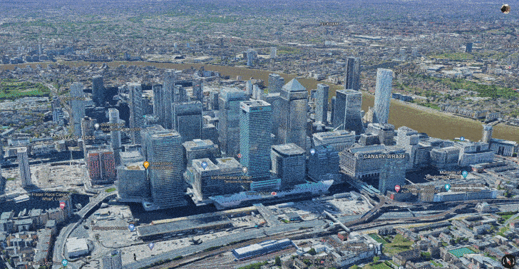
Canary Wharf from Google Maps
Urban challenges & urban sprawl
London’s population is growing at 5x the rate of houses being built, with a population increase of 100,000 per year. As a result, there is a housing shortage throughout London and south-east England, augmenting house prices. In 2020, there were 170,000 homeless in London, not helped by COVID making people redundant.
To combat this, either greenfield or brownfield sites need to be built on.
Greenfield sites:
- contribute to urban sprawl
- are usually from farmland, which produces food, or recreational land
- can destroy natural habitats
- are unlikely to turn back to countryside
- are fairly cheap due to the rurality
Brownfield sites:
- reduce the need for urban sprawl
- are more readily available due to the decline of industry
- may require buildings to be demolished prior to construction, but reduce dereliction
- can improve the pre-existing urban environment
- are more expensive due to usually being in rural areas
- may require the land to be decontaminated from chemicals and waste
Urban sprawl is the unplanned, rapid growth of urban areas. To combat this, many cities including London established a ‘green belt’ - an area around the city which has very strict planning permission. This has preserved areas of farmland and woodlands around London.
Being able to plan and control housing developments is why almost 50% of London’s land is ‘green’ and why there is almost a 1:1 resident: tree ratio!
However, this has had unintended consequences. The average house price in London is over double what it is in the rest of the UK, and rising rapidly. Many campaigners are pressuring the Government for less economically valuable areas to be used as greenfield sites to relieve the pressure on London’s housing crisis.
Another result of the green belt is the growth of commuter settlements around London. Reading is an example of this, being just a 30 minute train journey into the City of London (right in the middle) and outside the green belt, this has attracted many thousands of people and families to the town. This results in the spread of housing estates and business areas spreading into the countryside surrounding. Some may argue that this completely goes against the purpose of the green belt in the first place! (potential 9 marker)
The Lower Lea Valley
Alternately known as the place where the Olympic Park was built for 2012. (Stratford)
This area, prior to its restoration, was heavily contaminated with chemicals from industry. The industrial buildings were derelict and overgrown. On the other hand there were a couple of functioning industrial areas employing around 5,000 workers among 250 business.
The London 2012 Olympic Legacy was a plan to ensure the Olympic Games had significant long term benefits for the area.
ECONOMIC benefits
Stratford received a Tube station to connect it to the rest of London. It is now the second most connected area of the city! The Olympics directly resulted in £9 billion for east London, and Lloyds Bank estimated that another £10 billion will be generated from the Olympics. The media centre was sold to a data company, Infinity, who store data for large corporations. The total cost for the Olympics was £8.77 billion - from taxpayers.
However, the stadium cost £700 million, which was 3x the estimate.
SOCIAL benefits
The Athletes’ Village created for the Olympians has been repurposed (not demolished) as a housing estate called the East Village. Around 1,300 homes were made, most of which categorised as ‘affordable housing’. In total 8,000 people will be able to be housed. A school was also opened in the grounds of the park, relieving the shortage of space before it was built. The new pools built for the Olympics are now being used for this school, as well as the community, and also athletes training.
However, properties for poorer residents were demolished, including 450 flats. Few jobs were created for local residents during construction, and many thought it was a missed opportunity to train unskilled workers. As a result, many people round still live in poverty and in Tower Hamlets unemployment actually increased.
ENVIRONMENTAL
Many grounds in the Olympic Park have been kept as parkland for the public. Ponds, woodlands and artificial otter holes have been created in the area. The stadiums were made from 25% recycled material, and green spaces were placed along the River Lea to improve its water quality. It was built on over 500 acres of brownfield site, from derelict and contaminated land to newer, modern, loved areas. Over 300,000 plants were specially selected for biodiversity and sustainability in the urban environment.
However, many materials for the park were sourced from overseas, whilst the games produced over 3 million tons of CO2.
You don’t need to remember all the precise stats and figures - just a few - I have rounded some figures and simplified them a bit to make them easier to remember.
Urban living in East Village (again around the Olympic area).
Local bus and transport services connect to the London Underground, as well as Europe. Residents in the East Village pay extra for car parking places, encouraging cycling and walking.
Water is 50% less used than other urban areas, achieved by water recycling. Rainwater is recycled and filtered through ponds before being used for toilet flushing and irrigation. Green roofs on buildings also slow down rates of drainage, mitigating flood risk, and allowing more water to be used for irrigation or other conservation systems. (Drinking water is different!)
Energy is also conserved as it makes use of the combined heat and power system. It basically generates electricity, producing heat from burning biomass. This heat can be used to heat water. As it is piped through the village, it gently cools, and this cool water is piped back into the CHP station.
Green spaces have also been created. There are green roofs on apartments blocks, a wetland pond area, 10 hectares of open green space, a large central park and an orchard with fruit trees.7
Section C: The challenge of resource management
In this section, students are required to study Resource management and one from Food or Water or Energy.

You need to learn about all of them as an overview, but only one in particular, and food in more detail in this case.
Simply put, the more availability to food, water and energy a country has, the better the citizens’ well-beings are.
Quick summary of everything overall:
Food:
-
There is a growing demand for high-value food exports from low income countries and an all-year demand for seasonal food and organic produce. As a result of this, many countries, especially in Africa, have less land available for locals to cultivate on and support their families in. It reduces the water supply in areas where this is already unreliable - e.g. Kenya is on the equator, and many beans come from there. This increases the likelihood of droughts and desertification (paper 1 knowledge).
-
Carbon footprints are higher when outsourcing food supply to other countries, due to the increasing number of ‘food miles’ travelled. To combat this, there are moves towards local sourcing of food, with ‘locally sourced’ and ‘Red Tractor’ labels. Farm shops throughout the countryside also are well known to grow food on-site, albeit at a higher price. Organic produce is also gaining popularity which uses natural fertilisers and mechanical weeding, which does not pollute the water supply, and chemicals are not being ingested by humans who eat the food.
-
There is a trend towards agribusiness. This is when a farm is run large-scale with money-intensive commercial activities. This has resulted in fields increasing in size, with smaller farms being combined and the increased mechanisation of farm equipment. It also relies on pesticides and fertilisers more which has a negative impact on l’environnement and reduces employment. The positives include cheaper prices as food is more available and overhead costs have decreased, and skilled jobs with technology are provided to skilled workers.
Water:
- There is a changing demand for water in the UK. In northern areas, there is a high supply of water but low demand for it - the population density is low, with there only being a few cities. The reason why there is a lot of water here is because there is a lot orographic rainfall (mountains). In the south and southeast, there are low levels of waterfall and high levels of water stress, so transfer schemes are in place like dams and reservoirs on rivers to allow water to be moved from areas of water surplus to areas of water deficit - usually pumped.
The average person uses 150 litres of water in the UK per day
- This can only be done if the water quality is high and pollution is managed - toxic waste can poison wildlife, and eutrophication can kill plants due to plant life building up so much in the river or lake, reducing oxygen levels, suffocating the animals. Raw sewage and other waste must be treated at a treatment plant. It can also be managed by legislation, education campaigns, pollution traps and green roofs and walls.
Energy:
- the changing energy mix – reliance on fossil fuels, growing significance of renewables
- reduced domestic supplies of coal, gas and oil
- economic and environmental issues associated with exploitation of energy sources.
Food
Food, yummy. I really couldn’t live without it.
Food security is defined as ‘when all people at all times have access to sufficient, safe, nutritious food to maintain an active and healthy life’.
Worldwide, enough food is produced for everyone, but it is distributed differently. In mostly Africa and Southern Asia, there are high risks of food insecurity. In HICs, over 25% of the diet is made from meat, fish, eggs, milk and cheese and another quarter from cereals. In LICs, half the diet is made from cereals. Although high in calories, they are low in nutrients, resulting in malnourishment.
Several factors affect food supply and consumption:
Food demand factors
- Population growth: more mouths to feed requires more food to be produced. In LICs, where there is a deficit, everyone will get less nutrients.
- Economic development - as people in NEEs become more wealthy, they eat more meat and feed animals, resulting in resources being allocated for their own country rather than others.
- Climate - droughts can cause huge losses of crops and livestock, and also increasing the risks of desertification, reducing fertile farmland areas.
- Floods can also cause losses of crops and livestock, especially on coastal areas after tropical storms.
- Climate change is exaggerating these with weather patterns becoming more unpredictable while also increasing drought length and frequency of these and tropical storms.
- Not good.
- Technology - LICs cannot afford to invest in infrastructure which could increase yield of crops, like stable roads, machinery for cultivation and things like GM laboratories.
- Pests and disease - pests like rats can eat the produce in warehouses like silos after a harvest, diseases like malaria and cholera can reduce the workforce.
- Water stress - is when annual freshwater per person is below 1,700m3/year. HICs can manage water stress through transfer schemes and irrigation to produce food, while LICs can’t. Floods can also contaminate water supplies.
- Conflict & social unrest - wars can disrupt farming and food production. It also may displace many people who do not have the money or facilities to grow or buy food. The need for water can lead to international disputes over ownership of water sources, like in the River Nile.
Food supply factors
- Irrigation - used to supply extra water to farming areas, especially if water supply naturally is low. It increases crop yields and income, reducing poverty. If used economically, such as drip irrigation (delivered directly to roots reducing evaporation) it can improve the quality of live for everyone involved. However it can cause salinization (build up of salt) if the source is the sea, for example. It also costs a lot to maintain.
- Aeroponics - when air is used to grow plants. Nutritional water is sprayed to the plants regularly, in a greenhouse to avoid evaporation. It is easily maintainable, requires less nutrients as they do not go into the soil, and needs little space. It can be expensive and knowing the exact nutrients can require specialist knowledge.
- Hydroponics - when plants’ roots are constantly in water. They grow faster, like in aeroponics, as more nutrients are available. Diseases and funguses in the soil do not exist here. Similar disadvantages to aeroponics.
- The New Green Revolution - when new strains of seeds were developed with a higher yield. Yields increases by 40% in Asia and larger quantities of cheaper foods were produced. The New Green Revolution will conserve biodiversity while improving all aspects of farming and having the least impact on the environment.
- Biotechnology - GM crops and animals can be made to have more vitamins and proteins, more resistant to salts, droughts, insects and diseases, better flavours and better lifespan of foods after harvesting.
Aquaponics is when plants and animals are grown together - the fish produce nitrifying bacteria which give nitrates to the plant, increasing growth and yield.
Case study: Almeria, Spain
Almeria is a large scale agricultural development. Greenhouses cover 31,000 hectares of land. It is responsible for most of the UK’s out of season crops like tomatoes and cucumbers, generating 1.5 billion dollars for the Spanish economy. It supplies half of Europe’s fruit and vegetables. It has got so big because of:
- Changing demand for more fruit and veg
- High demand for out of season produce - HICs want this all year round
- Fast and easy shipping internationally
- Hot average temperature allowing for little extra energy to be required to grow the crops
- Cheap labour from (typically African) immigrants who want to earn money
Advantages include
- Low water use due to drip irrigation and hydroponics
- Fresh water via a desalination plant is available as it’s next to the Mediterranean Sea
- Jobs created in packing and manufacturing plants
- Very cheap produce produced
- Regulations increase food safety by reducing chemical uses.
Disadvantages include
- Immigrants are paid low wages and live and work in poor conditions
- The use of pesticides increase health risks for workers and contaminating water supplies
- Natural ecosystems have been COMPLETELY destroyed - there’s so much plastic covering everything!
- Natural water sources like aquifers are drying up
- Plastic pollution is being dumped in the sea affecting marine life
Temperatures in the area have dropped by 0.3oC in the area as the greenhouses are white and reflect sunlight!
[tbd] Example of a local scheme an LIC/NEE
This section is to be determined as I do not have any notes for it. I had to ask my teacher literally a couple of minutes before the exam about it, as it is right at the end of the specificaiton, for information which I just managed to remember.
Despite everyone else betting against me that it wouldn’t come up in the exam, it was the last question and a 6 marker in the 2022 exam series. Good luck!
Footnotes
1 I’m saying London here as, although it’s not (currently) a megacity, it’s always been a significant trading hub and economic powerhouse for the UK and globally.
2 The most waffle I’ve written today, almost as bad as my Chemistry 6 markers
4 Amended from Sam’s document. Lagos_Overview_-_Sam_Fisher_-_10th_Feb_-_10Q.docx
5 I spent ages looking and found this article on Wikipedia.
6 Credits to Jacob for this idea. discord link
7 How to get a free phone - just go here and eat as many apples as you can!
You’ve made it to the end!
Good luck with your exams!
Feel free to share this Cheat Sheet with friends, family and teachers.
Made with 💕 by Draggie