Debates - Hazardous Earth
3-marker limitation questions
To answer these questions, firstly understand what the question is asking. For example:
“Identify three limitations of Fig. 5 (graph) as a source of information about earthquakes occurring in Iran.”
This is effectively asking about how well it is a source of information about earthquakes. Therefore your answer must be about earthquake information and that’s it. Therefore, you should consider the properties of earthquakes, their effects, responses and more. For example, does the figure:
- Not contain essential information? This could be the magnitude, focus, people affected by it, why that specific location. If it is a map, why that area? Geology?
- Have a completely understandable scale? Pick out a year/month and can you get a precise reading? Is it going up in regular, precise intervals or random numbers of years?
- Have a reliable source? Is it from the USGS, the UNDRR, the EU?
- If statistics give, question why. Is it a raw number, or a more accurate proportion? Why is it just from one country - may it be beneficial to compare multiple?
Theory of Plate Tectonics
The theory of plate tectonics is closely linked with Alfred Wegener’s theory of continental drift, a theory completed in 1912 but rejected by scientific communities.

Reasons for plate movement
Paleomagnetism
Paleo (fossilised) magnetism is the record of historic magnetic changes as the Earth’s polarity changes (known as geomagnetic reversals), with recent polarity inverses occurring every 200 to 300 thousand years. When oceanographers mapped seabeds during WW2, magnetic flips were observed on either side of divergent boundaries and seafloor spreading centres. This is because as magma is erupted, it has high iron content. These iron particles within the erupted lava then cool quickly as a result of the water, solidifying the surrounding lava and preserving a record of the magnetic direction the iron was pointing in. There is a mirror image of the polarity inversals on either side of the plate boundary.
Glacial deposits
Evidence from previous glacial periods when the Pangea supercontinent existed reinforced the idea that at one point, land masses were connected. Striations, lines in rocks carved by glaciers moving other rocks over them, have been found by glaciologists in central India, Africa and even in the Amazon Rainforest.
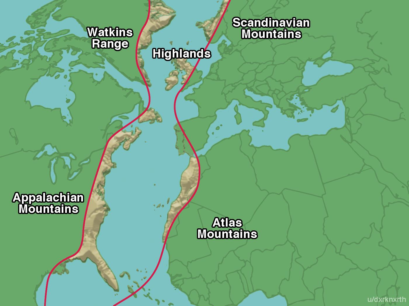
*A slightly exaggerated visualisation of the present-day positions of the Appalachian Mountain range. Thanks to
Dark North (u/dxrknxrth) and this Reddit post!
Apparent fit of the continents
He noticed that the continents look just like pieces of a broken puzzle…
Geologic sequences
Fossil evidence
Plate Boundaries
A plate boundary is where two plates meet. This is not the same as there being two plate boundaries! There is only one boundary and two plates.
Divergent plate boundaries
At a divergent plate boundary, two plates move apart from each other. Depending on the rate of movement and type of and density of the lithospheric crust, different landforms can be found
Oceanic-oceanic boundary
At a mid-oceanic ridge, molten magma rises towards the Earth’s surface, thanks to hot magma plumes within the mantle, originating from the lower mantle. As magma rises - caused by the force of the mantle plume - and enters the asthenosphere, it loses pressure and cools down. The lithospheric rocks above are pushed upwards by force, fracturing the lithosphere and penetrating through the crust. Accompanied by ridge push, at these ridges, thermal expansion from the presence of magma causes the surrounding rocks to… expand. Over time, vast chains of underwater mountains up to 3km tall and 60,000km in total length have formed.
At these oceanic ridge crests, landforms which are likely to be visible include black smokers (hydrothermal vents) where seawater meets the hot magma, as well as pillow lavas, which are mainly basaltic. These rocks once cooled can be used to indicate the upwards orientation at the time of eruption.
Variations in seafloor spreading velocity result in lateral transform faults, which appear as zig-zags on topographic ocean maps. Due to the accumulating pressure and tension as these masses move, small earthquakes will likely occur due to, releasing kinetic energy. (There is little volcanic activity along transform faults.)
A transform fault is only the lateral part of the zig-zag, between ocean ridge crests.
Continental-continental
In locations where two continental plates meet (such as the East African Rift: Nubial <–> Somali), the mantle plume is not as strong, if any at all. As a result, rift valleys are created and are visible on land (such as in Iceland). These form as the plates, being pulled away from each other due to convection currents fuelling slab pull, resulting in the land at the boundary sinking: there is nothing below supporting it. Volcanic fissures also may open up for a time if there is land movement and a magma chamber beneath, which look like lines of magma erupting over a landscape. Shield volcanoes erupt viscous lava and are less active compared to composite volcanoes and calderas.
Rift valleys can also be found where spreading is occurring at a slower rate, such as the Mid-Atlantic Ridge (North American <–> Eurasian) on land such as Iceland.
Convergent plate boundaries
-
upthrust of lithospheric rock creating high altitude fold mountains e.g. Himalayas on continental-continental. Big, shallow focus earthquakes
-
responsible for deep ocean trenches e.g. Mariana and Java Trench on continental-oceanic and oceanic-oceanic boundaries
-
oceanic plate subducts, melting in the asthenosphere. As a result there is explosive volcanic activity, and shallow focus earthquakes, tsunamis and most dangerous boundary
-
oceanic-oceanic also forms island arcs. Antilles and Aleutian
(explain from memory)
Conservative plate boundaries
Typically continental plates move past in a strike-slip shearing motion.
No crust destroyed, no magma created, no volcanoes
However there are very big earthquake potenial
(explain from memory)
Conservative boundaries are also referred to as transform plate boundaries (wording in the USA only)
Volcanoes
The chemistry of an eruption
The nature of a volcanic eruption is shaped by a range of factors. For example, the viscosity, or the ‘stickiness’ of magma. The viscosity measures the resistance to flow an, in the case of volcanic activity, the more viscous it is, the more explosively the eruption may be.
Additionally, the gas inside the magma chamber drives the flow of the magma through the mantle and crust. Gas can build up within the magma chamber, forcing the magma to be quickly discharged and causing a more explosive eruption. Other factors can include the pipe’s shape. The length and diameter of it can cause differing explosion types, with typically short, narrow pipes creating greater explosions.
Magma is made of molten rock crystals which grow as the liquid inside cools down. Gas bubbles can make this more porous, viscosity and chemistry of the melt and temperature can change the characteristics of magma. The chemistry of magma refers to the polymerisation state of the liquid. Remember GCSE chemistry? Polymers are long chains of molecules; if these contain silica and oxygen inside, it become more viscous. Acidic, rhyolitic lava is characteristic of this chemistry, from typically converging boundaries.
Alkaline and H2O molecules break up these polymers into smaller, simple molecules which flow more easily and are typically basaltic.
To simplify the remembrance of the formation and type of magma, have a look at this table and see if you notice a pattern.
| Explosive eruptions | Effusive eruptions |
|---|---|
| Typically forms at converging boundaries | Typically forms at diverging boundaries or hotspots |
| Formed as a result of subduction | Formed from a deep mantle plume, or from ridge pull |
| Temperatures cooler, at around 750 | Hot temperatures at 1000+ degrees |
| Sticky, viscous magma | Runny, low viscosity magma |
| Acidic | Less acidic |
| Cannot travel far, builds up a distinctive cone around a volcano | Travels far and fairly flat, a ‘shield’ shape. You may not know it is a volcano at all. |
| Rhyolitic magma | Basaltic magma |
| Distinct central vent and perhaps several side vents | Fissure eruptions common |
| Less unpredictable but infrequent | More unpredictable, but more frequent |
| Recurrence intervals can range from several years to several thousand+ years | Recurrence intervals are very frequent, even once per day |
| Examples include Mt Pinatubo, Mt. St. Helens, | Examples include Iceland, Hawaii |
Intrusive volcanicity
Hotspot volcanoes
Yellowstone supervolcano
Stratovolcanoes
Cone-shaped formed by explosive extrusive volcanicity. Due to high viscosity, typically near a converging boundary, caused by long-length silica-rich acidic polymers due to the mixture of hot asthenospheric material and subducted plate debris which contains H2O, gases and other material from the ocean floor. This results in more gases developing, rising upwards and mixed in viscous, relatively cool (~600-800 degrees C) rhyolitic magma chambers. The explosive eruptions occur when the magma pushed by gases reaches the surface. The high viscosity causes the lava to not travel long distances. Over time, ash and lava will solidify in strata, building up around the central volcanic funnel causing the characteristic dome shape.
Shield Volcanoes
Effusive, basaltic eruption causes these as low-length polymerisation of the lava allows for higher temperatures (>1000degrees) and less viscosity, enabling long-distance transport after the initial extrusion.
East African Rift Valley
The African Plate is splitting in two! Land is dropping down due to ridge push and convection. There are also volcanic mountains
Volcano Case Studies
- Mitigating the event is a costly method of reducing the effects of an eruption as it is occurring - e.g. ash wall construction and lowering concrete barriers from helicopters in Etna, spraying water on lava to cool and slow it down in Iceland
- Mitigating against vulnerability is preparing the community and planning for hazards to occur. Indonesia’s Centre for Volcanology and Geological Hazard Mitigation is… [tbd]
- Managing losses is how the event is responded to. Well-trained search and rescue teams and temporary shelter provisioning are perhaps key to reducing the impact of an eruption. EDCs such as Indonesia may be the most adept to dealing with these.
Case study: Eyjafjallajökull, Iceland
Iceland, in 2010, had a HDI of 0.92 and a GNI per capita of US$36,270 PPP, with a life expectancy of 82.
Eyjafjallajokull is a stratovolcano covered in glacial ice. Volcanic events starting in March 2010 began effusively, with characteristic basaltic andesitic lava. This attracted some tourists to the area, and ash reached no more than 4km in the atmosphere - a VEI 2 eruption.
In April 2010, the second, most significant explosive eruption occurred, peaking at a VEI of 4. This was particularly damaging for many reasons. It was directly below the very stable jet stream, pushing wind towards the UK and Europe. The eruption took place under 200m of glacial ice, with much of the meltwater flowing back into the caldera increasing the explosivity with high gases and increased pressure. This also caused glass-rich ash to be formed quickly which was injected into the troposphere at above 10km in altitude, which moved its way along Western and Central Europe.

Impacts on people
Many farm crops and roads were washed away from glacial jökulhlaups, and fish exports from the Icelandic offshore fishing industry were halted due to the ash. Around 800 nearby residents were evacuated from large trucks and members of the fire brigade. Because of good infrastructure, warning systems and education, there were no direct deaths from the eruption.
On the continent, over 100,000 flights were cancelled, affecting 7 million passengers exacerbated by the Easter school holiday season. It is estimated that the GDP loss of the entire EU from this was $2.6bn with airlines losing $1.7bn. This had a knock-on effect for those reliant on the tourism industry, which is highly volatile and depends on revenue during these periods. London lost over £102mn and some companies were never able to recover from this. On top of 400,000 Britons stranded globally due to the three major London airports being closed - almost 1% of the population - this was particularly damaging.
Just-in-time manufacturing and trade as a result of globalisation such as the transport of Kenyan flowers cost the horticultural industry around $3mn per day, with 5 thousand flower and vegetable farmers who rely on a source of stable income in LIDCs being temporarily laid off. (97% of flowers are delivered to Europe, which is difficult when the whole airspace is closed!)
“Volcano tourism” has increased sharply since the eruption, with people going to visit the geological landforms and effusive activity like lava streams across the country. Tourist levels were 43% above forecast levels, with almost 80,000 additional visits. These people spend an average of ~$2000 each, generating significant revenue for the country.
“The increase in Icelandic tourism was far greater than the previous decline caused by the natural disaster and greatly exceeded forecasts.” [1]. This clearly shows how it can be a benefit to countries which can successfully mitigate against vulnerability, losses and the event itself.
How to pronounce
Case study: Volcan del Fuego, Guatemala
Guatemala is an LIDC in Central America with an HDI of 0.627 and GNI/capital of $8,500 PPP.
The eruption in 2018 was Guatemala’s deadliest event since 1902. It killed over 200 people with a VEI 3-4 plume reaching 15.2km. There was no hazard plan, and despite being one of the most active volcanoes along the Pacific Ring of Fire, it seems that people did not fully understand the risks. Bodies in 6 destroyed villages were found not far from homes, corroborating with video footage of people simply staring at the ash cloud and oncoming pyroclastic flows. Coupled with the fact that there was no evacuation alert issued, this shows that the infrastructure and investment were simply inadequate in the region.
Efforts to evacuate the area were rendered difficult due to inaccurate data involving road access, population size and population locations in proximity to the volcano’s flanks prone to pyroclastic flows. The Guatemalan Mountain Rescue Brigade were already searching for a missing person when explosive activity increased, and were able to help a significant but unknown number of people in surrounding villages to evacuate, emphasising the need for well-trained and experienced individuals for mitigation of vulnerability. Mitigation of losses could have been better but was not totally inadequate: firefighters were immediately deployed to the area with the aim of recovering trapped people and bodies, however, the heat and nature of the pyroclastics simply incinerated many buildings. 6,000 people were eventually evacuated as lava flows continued into the night and temporary shelters were provisioned with priority given to women and children, showing that there was at least some emergency provisioning.
Case study: Mount Nyiragongo, DRC, May 2021
Mountain Nyiragongo is situated on a continental divergent plate boundary, resulting in effusive eruptions. The world’s largest lava lake is situated in the volcano, which is a cinter cone, and it began to grow and show increased activity. However, the Goma Volcano Observatory was unable to successfully pay for Internet connections to remotely monitor the volcanic activity on instruments, or staff fuel to take measurements due to a withdrawal of World Bank funding due to allegations of government corruption one year prior. Goma is the provincial capital city of 2,000,000 inhabitants around 15 kilometres to the South.
As a result, only one warning was issued for an imminent eruption a fortnight preceding the May eruption. Three vents opened on the cinder cone’s flanks, which flowed towards Goma at a rate of around 1 kilometre per hour, allowing around 20 hours for people to escape. Around 30 two people died, mostly used to asphyxiation - the invisible, toxic CO2 gathers in low-lying areas. Whilst there was an evacuation warning of 400,000 people as a result of the city evacuation plan and a third of the population moved quickly, 2000 homes were destroyed and 17 villages were ruined.
However, this LIDC eruption was much better handled compared to the eruption in 2002, where 10x more people died and 13% of the city was destroyed, rendering 120,000 homeless. People in Goma were evidently more prepared this time, showing how far a small warning system and prior community knowledge can help mitigate vulnerability.
Case study: Mount Merapi, Indonesia
Indonesia is an EDC with an HDI of 0.705 and GNI per capita of $4,580 in 2022. It is in a very unstable tectonic region, with the Sunda Trench being the subduction zone between the Indo-Australian plate to the south and east, and the continental Eurasian plate to the north. There are 130 active volcanoes in Indonesia and, as a result, 70% of the 273 million inhabitants live within 100km of an active volcano - within range of damaging distances to historic VEI 6 and 7 eruptions of Tambora and Krakatau. 8.6 million are within 10km of these volcanoes - the range of a pyroclastic flow.
Quick facts:
- Eruption occurred in October 2010. Peak VEI of 4 - deadliest in 150 years
- 353 people died, mostly due to close proximity pyroclastic flows
- 350,000 evacuated from the areas in hazard zones 1, 2 and 3
- Many people returned as the eruption was still ongoing. It lasted over a month from 25th October to the end of November
50,000 people are living on Mt. Merapi’s slopes, within the most dangerous hazard Zone 3. This is primarily due to the agricultural benefits of volcano flanks:
- Ash deposits are rich in potassium and phosphorous. Combined with added relief rainfall and being in a tropical equatorial region, there is plenty of water to supply large swaths of agricultural regions
- Infrastructure such as electricity and telecommunications already exists in the region, reducing the amount of pull factors to move into urban regions such as Yogyakarta to the south.
- However, although risk perception is high, it may have been overridden by a sense of dependence on the land - they may not have a financial buffer compared to when Eyjafjallajokull erupted with the same VEI in the same year.
Mitigation strategies have been partially successful. The local Javanese government compensated many thousands of farmers with plots of land elsewhere to discourage the continued inhabitation of the flanks.
Indonesia has very well-prepared, experienced and equipped emergency services. In addition, there is a constant clearance of flood and river channels to reduce the impact of lahars, which were seen, especially due to the Equatorial nature of the country, and pyroclastic flows might have on the population, of which there were over a dozen during Mount Merapi’s eruption in 2010. In addition, local governments have been able to provide hundreds of thousands of people with emergency shelters, some of which end up becoming permanent settlements, which are much futher away from the volcano itself, mitigating vulnerabilities further. However, despite this apparent organisation, the shelters are also prone to disease outbreaks. The “mass exodus” of people who the shelters have been occupied by have historically has involved many children becoming severely injured and separated from their parents and their families. Despite allegations of corruption, local governments’ responses during national disasters remain excellent, including aid delivery from both internal and external means.
Despite the local government’s demonstration of regularly clearing valleys from debris, there can be no replacement for ensuring that people are moved away from the stratovolcano’s flanks and provided access to another area - something which has been done for those in zone 3. However, for an EDC with some of the fastest-growing populations and high population densities supporting 1,000/km2 even in remote areas of Java, a balance seems to have been struck by successfully modifying the vulnerability to a large extent whilst not investing huge amount of money to save less and less residents who do simply do not wish to move.
Strategies to manage volcanic hazards
Mitigating against events
Humans cannot stop volcanic hazards